Grünendeich geodata
Grünendeich (Lower Saxony) is a seat of a fourth-order administrative division; located in Germany in Europe/Berlin (GMT+2) time zone. With population of 2,061 people, there are 4981 cities with bigger population in this country. Compared to other cities in Germany, 86.5% of cities are located further ↓South; 55.9% of cities are located further →East and 98.1% of cities have higher elevation than Grünendeich. Note1


Grünendeich GPS coordinates[2]
53° 34' 10.272" North, 9° 36' 43.848" East
| Map corner | latitude | longitude |
|---|---|---|
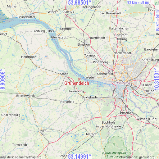
| Upper-left | 53.98501°, | 8.90906° |
| Center: | 53.56952°, | 9.61218° |
| Lower-right: | 53.14991°, | 10.31531° |
| Map W x H: | 92.9×92.9 km | = 57.7×57.7mi |
| max Lat: | 55.01917° ⇑13.5% North |
| Grünendeich: | 53.56952° |
| min Lat: | ⇓86.5% South 47.40724° |
| min Long | Grünendeich | max Long |
| 5.92978° | 9.61218° | 14.98853° |
| W 44.1%⇐ | ⇒55.9% E |
Elevation
Elevation of Grünendeich is 2 m = 7 ft, and this is 247.1 m = 811 ft below average elevation for this country.
| Max E: |
1256 m = 4121 ft | 98.1% |
| Avg. | 249.1 m = 817 ft | |
| Grünendeich | 2 m = 7 ft | |
Min E: |
-5 m = -16 ft | 1.9% |
See also: Germany elevation on elevation.city.
Geographical zone
Grünendeich is located in North temperate zone (between Tropic of Cancer and the Arctic Circle). Distance of this North polar circle is 1444.8 km =897.8 mi to North.| Distance of | km | miles | from Grünendeich |
|---|---|---|---|
| North Pole | 4050.7 | 2517 | to North |
| Arctic Circle | 1444.8 | 897.8 | to North |
| Tropic Cancer | 3350.5 | 2081.9 | to South |
| Equator | 5956.4 | 3701.1 | to South |


Nearby cities:
15 places around Grünendeich: (largest is in red/bold)
• Agathenburg
5.4 km =3.4 mi,  259°
259°
• Dollern
5.8 km =3.6 mi,  225°
225°
• Guderhandviertel
2.3 km =1.4 mi,  184°
184°
• Haseldorf
7.7 km =4.8 mi,  349°
349°
• Heist
9.3 km =5.8 mi,  15°
15°
• Hetlingen
4.5 km =2.8 mi, 21°
• Holm
6.4 km =4 mi,  34°
34°
• Horneburg
7.4 km =4.6 mi,  199°
199°
• Jork
6.2 km =3.9 mi,  132°
132°
• Mittelnkirchen
3.1 km =1.9 mi,  166°
166°
• Neuenkirchen
5.9 km =3.7 mi,  187°
187°
• Nottensdorf
9.6 km =6 mi, 184°
• Stade
9.4 km =5.8 mi,  286°
286°
• Steinkirchen
0.4 km =0.2 mi, 190°
• Wedel
5.9 km =3.7 mi,  74°
74°
Sources, notices
• [Note1] Compared only with cities in Germany existing in our database
• [Src1] Map data: © OpenStreetMap contributors (CC-BY-SA)
• [Src2] Other city data from geonames.org with taken over terms of usage.
• [Src3] Geographical zone / Annual Mean Temperature by Robert A. Rohde @ Wikipedia
