Dinklage geodata
Dinklage (Lower Saxony) is a populated place; located in Germany in Europe/Berlin (GMT+2) time zone. With population of 12,626 people, there are 1281 cities with bigger population in this country. Compared to other cities in Germany, 79.3% of cities are located further ↓South; 75.1% of cities are located further →East and 87.3% of cities have higher elevation than Dinklage. Note1


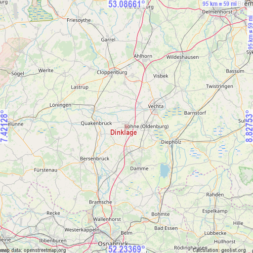
Dinklage GPS coordinates[2]
52° 39' 44.028" North, 8° 7' 27.84" East
| Map corner | latitude | longitude |
|---|---|---|
| Upper-left | 53.08661°, | 7.42128° |
| Center: | 52.66223°, | 8.1244° |
| Lower-right: | 52.23369°, | 8.82753° |
| Map W x H: | 94.8×94.8 km | = 58.9×58.9mi |
| max Lat: | 55.01917° ⇑20.7% North |
| Dinklage: | 52.66223° |
| min Lat: | ⇓79.3% South 47.40724° |
| min Long | Dinklage | max Long |
| 5.92978° | 8.1244° | 14.98853° |
| W 24.9%⇐ | ⇒75.1% E |
Elevation
Elevation of Dinklage is 29 m = 95 ft, and this is 220.1 m = 722 ft below average elevation for this country.
| Max E: |
1256 m = 4121 ft | 87.3% |
| Avg. | 249.1 m = 817 ft | |
| Dinklage | 29 m = 95 ft | |
Min E: |
-5 m = -16 ft | 12.7% |
See also: Germany elevation on elevation.city.
Geographical zone
Dinklage is located in North temperate zone (between Tropic of Cancer and the Arctic Circle). Distance of this North polar circle is 1545.7 km =960.5 mi to North.| Distance of | km | miles | from Dinklage |
|---|---|---|---|
| North Pole | 4151.6 | 2579.7 | to North |
| Arctic Circle | 1545.7 | 960.5 | to North |
| Tropic Cancer | 3249.6 | 2019.2 | to South |
| Equator | 5855.5 | 3638.4 | to South |


Nearby cities:
15 places around Dinklage: (largest is in red/bold)
• Badbergen
10 km =6.2 mi,  251°
251°
• Bakum
10 km =6.2 mi,  28°
28°
• Bersenbrück
17.1 km =10.6 mi,  224°
224°
• Bühren
17.2 km =10.7 mi,  21°
21°
• Cappeln
16.5 km =10.3 mi,  357°
357°
• Damme
16.4 km =10.2 mi,  162°
162°
• Essen
14.3 km =8.9 mi,  297°
297°
• Gehrde
12.5 km =7.8 mi, 220°
• Holdorf
8.8 km =5.5 mi,  183°
183°
• Lohne
7.6 km =4.7 mi,  86°
86°
• Neuenkirchen
17.4 km =10.8 mi,  193°
193°
• Quakenbrück
11.9 km =7.4 mi,  276°
276°
• Rüsfort
11.5 km =7.1 mi,  228°
228°
• Steinfeld
10.4 km =6.5 mi,  144°
144°
• Vechta
13 km =8.1 mi,  56°
56°
Sources, notices
• [Note1] Compared only with cities in Germany existing in our database
• [Src1] Map data: © OpenStreetMap contributors (CC-BY-SA)
• [Src2] Other city data from geonames.org with taken over terms of usage.
• [Src3] Geographical zone / Annual Mean Temperature by Robert A. Rohde @ Wikipedia
