Cappeln geodata
Cappeln (Lower Saxony) is a populated place; located in Germany in Europe/Berlin (GMT+2) time zone. With population of 6,274 people, there are 2375 cities with bigger population in this country. Compared to other cities in Germany, 80.5% of cities are located further ↓South; 75.2% of cities are located further →East and 79.9% of cities have higher elevation than Cappeln. Note1
Administrative division(s):
- Level 1: Lower Saxony
- Level 3: Landkreis Cloppenburg
- Level 4: Cappeln (Oldenburg)


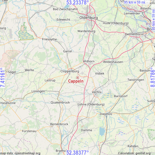
Cappeln GPS coordinates[2]
52° 48' 39.06" North, 8° 6' 53.064" East
| Map corner | latitude | longitude |
|---|---|---|
| Upper-left | 53.23378°, | 7.41161° |
| Center: | 52.81085°, | 8.11474° |
| Lower-right: | 52.38377°, | 8.81786° |
| Map W x H: | 94.5×94.5 km | = 58.7×58.7mi |
| max Lat: | 55.01917° ⇑19.5% North |
| Cappeln: | 52.81085° |
| min Lat: | ⇓80.5% South 47.40724° |
| min Long | Cappeln | max Long |
| 5.92978° | 8.11474° | 14.98853° |
| W 24.8%⇐ | ⇒75.2% E |
Elevation
Elevation of Cappeln is 47 m = 154 ft, and this is 202.1 m = 663 ft below average elevation for this country.
| Max E: |
1256 m = 4121 ft | 79.9% |
| Avg. | 249.1 m = 817 ft | |
| Cappeln | 47 m = 154 ft | |
Min E: |
-5 m = -16 ft | 20.1% |
See also: Germany elevation on elevation.city.
Geographical zone
Cappeln is located in North temperate zone (between Tropic of Cancer and the Arctic Circle). Distance of this North polar circle is 1529.2 km =950.2 mi to North.| Distance of | km | miles | from Cappeln |
|---|---|---|---|
| North Pole | 4135 | 2569.4 | to North |
| Arctic Circle | 1529.2 | 950.2 | to North |
| Tropic Cancer | 3266.1 | 2029.5 | to South |
| Equator | 5872 | 3648.7 | to South |


Nearby cities:
15 places around Cappeln: (largest is in red/bold)
• Bakum
9.5 km =5.9 mi,  144°
144°
• Bühren
7 km =4.3 mi,  94°
94°
• Cloppenburg
6.2 km =3.9 mi,  311°
311°
• Dinklage
16.5 km =10.3 mi,  177°
177°
• Emstek
3.4 km =2.1 mi,  43°
43°
• Essen
15.5 km =9.6 mi,  230°
230°
• Garrel
16.8 km =10.4 mi,  336°
336°
• Goldenstedt
21.5 km =13.4 mi,  96°
96°
• Großenkneten
17.5 km =10.9 mi,  32°
32°
• Lastrup
16.7 km =10.4 mi,  263°
263°
• Lohne
18.1 km =11.2 mi,  152°
152°
• Molbergen
13.8 km =8.6 mi,  292°
292°
• Quakenbrück
18.7 km =11.6 mi,  216°
216°
• Vechta
14.9 km =9.3 mi,  129°
129°
• Visbek
13.8 km =8.6 mi,  79°
79°
Sources, notices
• [Note1] Compared only with cities in Germany existing in our database
• [Src1] Map data: © OpenStreetMap contributors (CC-BY-SA)
• [Src2] Other city data from geonames.org with taken over terms of usage.
• [Src3] Geographical zone / Annual Mean Temperature by Robert A. Rohde @ Wikipedia
