Bakum geodata
Bakum (Lower Saxony) is a seat of a fourth-order administrative division; located in Germany in Europe/Berlin (GMT+2) time zone. With population of 5,678 people, there are 2574 cities with bigger population in this country. Compared to other cities in Germany, 80% of cities are located further ↓South; 74.2% of cities are located further →East and 85.4% of cities have higher elevation than Bakum. Note1


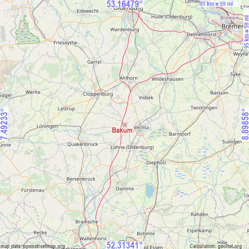
Bakum GPS coordinates[2]
52° 44' 28.248" North, 8° 11' 43.656" East
| Map corner | latitude | longitude |
|---|---|---|
| Upper-left | 53.16479°, | 7.49233° |
| Center: | 52.74118°, | 8.19546° |
| Lower-right: | 52.31341°, | 8.89858° |
| Map W x H: | 94.7×94.7 km | = 58.8×58.8mi |
| max Lat: | 55.01917° ⇑20% North |
| Bakum: | 52.74118° |
| min Lat: | ⇓80% South 47.40724° |
| min Long | Bakum | max Long |
| 5.92978° | 8.19546° | 14.98853° |
| W 25.8%⇐ | ⇒74.2% E |
Elevation
Elevation of Bakum is 34 m = 112 ft, and this is 215.1 m = 706 ft below average elevation for this country.
| Max E: |
1256 m = 4121 ft | 85.4% |
| Avg. | 249.1 m = 817 ft | |
| Bakum | 34 m = 112 ft | |
Min E: |
-5 m = -16 ft | 14.6% |
See also: Germany elevation on elevation.city.
Geographical zone
Bakum is located in North temperate zone (between Tropic of Cancer and the Arctic Circle). Distance of this North polar circle is 1536.9 km =955 mi to North.| Distance of | km | miles | from Bakum |
|---|---|---|---|
| North Pole | 4142.8 | 2574.2 | to North |
| Arctic Circle | 1536.9 | 955 | to North |
| Tropic Cancer | 3258.4 | 2024.7 | to South |
| Equator | 5864.3 | 3643.9 | to South |


Nearby cities:
15 places around Bakum: (largest is in red/bold)
• Badbergen
18.7 km =11.6 mi,  230°
230°
• Bühren
7.4 km =4.6 mi,  12°
12°
• Cappeln
9.5 km =5.9 mi,  324°
324°
• Cloppenburg
15.6 km =9.7 mi, 319°
• Diepholz
18.9 km =11.7 mi,  141°
141°
• Dinklage
10 km =6.2 mi,  208°
208°
• Emstek
10.7 km =6.6 mi,  343°
343°
• Essen
17.5 km =10.9 mi,  263°
263°
• Goldenstedt
16.8 km =10.4 mi,  71°
71°
• Holdorf
18.3 km =11.4 mi,  196°
196°
• Lohne
8.8 km =5.5 mi,  161°
161°
• Quakenbrück
18.1 km =11.2 mi,  246°
246°
• Steinfeld
17.3 km =10.7 mi,  175°
175°
• Vechta
6.3 km =3.9 mi,  105°
105°
• Visbek
13.1 km =8.1 mi,  38°
38°
Sources, notices
• [Note1] Compared only with cities in Germany existing in our database
• [Src1] Map data: © OpenStreetMap contributors (CC-BY-SA)
• [Src2] Other city data from geonames.org with taken over terms of usage.
• [Src3] Geographical zone / Annual Mean Temperature by Robert A. Rohde @ Wikipedia
