Demmin geodata
Demmin (Mecklenburg-Vorpommern) is a populated place; located in Germany in Europe/Berlin (GMT+2) time zone. With population of 12,495 people, there are 1299 cities with bigger population in this country. Compared to other cities in Germany, 91.4% of cities are located further ↓South; 92.5% of cities are located further ←West and 94.8% of cities have higher elevation than Demmin. Note1
Administrative division(s):
- Level 1: Mecklenburg-Vorpommern
- Level 3: Mecklenburgische Seenplatte
- Level 4: Demmin, Hansestadt


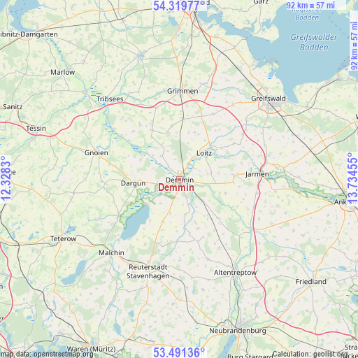
Demmin GPS coordinates[2]
53° 54' 27.432" North, 13° 1' 53.112" East
| Map corner | latitude | longitude |
|---|---|---|
| Upper-left | 54.31977°, | 12.3283° |
| Center: | 53.90762°, | 13.03142° |
| Lower-right: | 53.49136°, | 13.73455° |
| Map W x H: | 92.1×92.1 km | = 57.2×57.2mi |
| max Lat: | 55.01917° ⇑8.6% North |
| Demmin: | 53.90762° |
| min Lat: | ⇓91.4% South 47.40724° |
| min Long | Demmin | max Long |
| 5.92978° | 13.03142° | 14.98853° |
| W 92.5%⇐ | ⇒7.5% E |
Elevation
Elevation of Demmin is 9 m = 30 ft, and this is 240.1 m = 788 ft below average elevation for this country.
| Max E: |
1256 m = 4121 ft | 94.8% |
| Avg. | 249.1 m = 817 ft | |
| Demmin | 9 m = 30 ft | |
Min E: |
-5 m = -16 ft | 5.2% |
See also: Germany elevation on elevation.city.
Geographical zone
Demmin is located in North temperate zone (between Tropic of Cancer and the Arctic Circle). Distance of this North polar circle is 1407.2 km =874.4 mi to North.| Distance of | km | miles | from Demmin |
|---|---|---|---|
| North Pole | 4013.1 | 2493.6 | to North |
| Arctic Circle | 1407.2 | 874.4 | to North |
| Tropic Cancer | 3388 | 2105.2 | to South |
| Equator | 5994 | 3724.5 | to South |


Nearby cities:
15 places around Demmin: (largest is in red/bold)
• Alt Tellin
15.6 km =9.7 mi,  116°
116°
• Beggerow
9 km =5.6 mi,  170°
170°
• Bentzin
16.4 km =10.2 mi,  74°
74°
• Borrentin
11.7 km =7.3 mi,  201°
201°
• Dargun
11.9 km =7.4 mi,  266°
266°
• Düvier
12.2 km =7.6 mi,  11°
11°
• Glewitz
14.3 km =8.9 mi,  330°
330°
• Kruckow
13.7 km =8.5 mi,  92°
92°
• Nossendorf
7.7 km =4.8 mi,  322°
322°
• Sarow
13.4 km =8.3 mi,  160°
160°
• Stubbendorf
15 km =9.3 mi,  288°
288°
• Tutow
14.2 km =8.8 mi, 86°
• Warsow
15.9 km =9.9 mi,  244°
244°
• Zarnekow
8.9 km =5.5 mi, 265°
• Ückeritz
10.2 km =6.3 mi,  80°
80°
Sources, notices
• [Note1] Compared only with cities in Germany existing in our database
• [Src1] Map data: © OpenStreetMap contributors (CC-BY-SA)
• [Src2] Other city data from geonames.org with taken over terms of usage.
• [Src3] Geographical zone / Annual Mean Temperature by Robert A. Rohde @ Wikipedia
