Warsow geodata
Warsow (Mecklenburg-Vorpommern) is a populated place; located in Germany in Europe/Berlin (GMT+2) time zone. With population of 718 people, there are 8237 cities with bigger population in this country. Compared to other cities in Germany, 90.6% of cities are located further ↓South; 90.8% of cities are located further ←West and 90.5% of cities have higher elevation than Warsow. Note1
Administrative division(s):
- Level 1: Mecklenburg-Vorpommern
- Level 3: Mecklenburgische Seenplatte
- Level 4: Neukalen


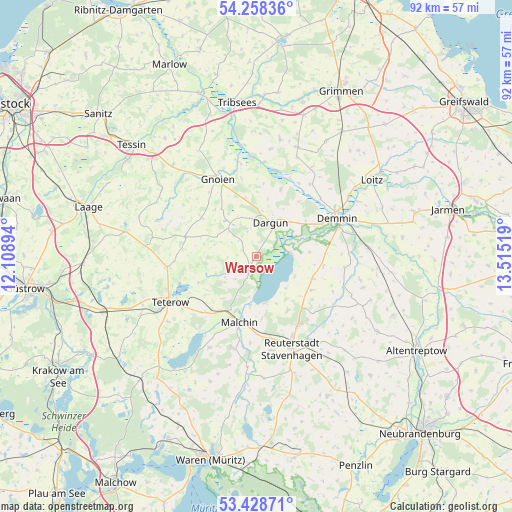
Warsow GPS coordinates[2]
53° 50' 44.124" North, 12° 48' 43.416" East
| Map corner | latitude | longitude |
|---|---|---|
| Upper-left | 54.25836°, | 12.10894° |
| Center: | 53.84559°, | 12.81206° |
| Lower-right: | 53.42871°, | 13.51519° |
| Map W x H: | 92.2×92.2 km | = 57.3×57.3mi |
| max Lat: | 55.01917° ⇑9.4% North |
| Warsow: | 53.84559° |
| min Lat: | ⇓90.6% South 47.40724° |
| min Long | Warsow | max Long |
| 5.92978° | 12.81206° | 14.98853° |
| W 90.8%⇐ | ⇒9.2% E |
Elevation
Elevation of Warsow is 20 m = 66 ft, and this is 229.1 m = 752 ft below average elevation for this country.
| Max E: |
1256 m = 4121 ft | 90.5% |
| Avg. | 249.1 m = 817 ft | |
| Warsow | 20 m = 66 ft | |
Min E: |
-5 m = -16 ft | 9.5% |
See also: Germany elevation on elevation.city.
Geographical zone
Warsow is located in North temperate zone (between Tropic of Cancer and the Arctic Circle). Distance of this North polar circle is 1414.1 km =878.7 mi to North.| Distance of | km | miles | from Warsow |
|---|---|---|---|
| North Pole | 4020 | 2497.9 | to North |
| Arctic Circle | 1414.1 | 878.7 | to North |
| Tropic Cancer | 3381.1 | 2100.9 | to South |
| Equator | 5987.1 | 3720.2 | to South |


Nearby cities:
15 places around Warsow: (largest is in red/bold)
• Altkalen
7.6 km =4.7 mi,  321°
321°
• Beggerow
15.9 km =9.9 mi,  97°
97°
• Borrentin
10.9 km =6.8 mi,  111°
111°
• Dargun
6.6 km =4.1 mi,  22°
22°
• Demmin
15.9 km =9.9 mi,  64°
64°
• Gnoien
15.2 km =9.4 mi,  334°
334°
• Jördenstorf
13.3 km =8.3 mi,  285°
285°
• Kummerow
8.7 km =5.4 mi,  170°
170°
• Lelkendorf
5.3 km =3.3 mi,  266°
266°
• Malchin
12.1 km =7.5 mi,  194°
194°
• Neukalen
2.9 km =1.8 mi,  209°
209°
• Nossendorf
16.2 km =10.1 mi,  36°
36°
• Remplin
12.7 km =7.9 mi,  216°
216°
• Stubbendorf
11.6 km =7.2 mi,  0°
0°
• Zarnekow
8.3 km =5.2 mi, 41°
Sources, notices
• [Note1] Compared only with cities in Germany existing in our database
• [Src1] Map data: © OpenStreetMap contributors (CC-BY-SA)
• [Src2] Other city data from geonames.org with taken over terms of usage.
• [Src3] Geographical zone / Annual Mean Temperature by Robert A. Rohde @ Wikipedia
