Delitzsch geodata
Delitzsch (Saxony) is a populated place; located in Germany in Europe/Berlin (GMT+2) time zone. With population of 24,998 people, there are 590 cities with bigger population in this country. Compared to other cities in Germany, 66.6% of cities are located further ↓South; 86.2% of cities are located further ←West and 68.8% of cities have higher elevation than Delitzsch. Note1


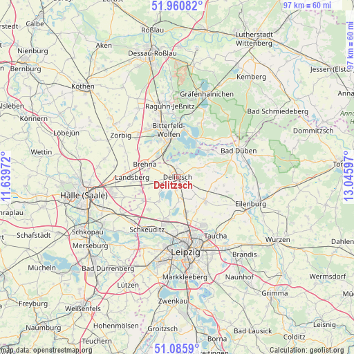
Delitzsch GPS coordinates[2]
51° 31' 31.656" North, 12° 20' 34.224" East
| Map corner | latitude | longitude |
|---|---|---|
| Upper-left | 51.96082°, | 11.63972° |
| Center: | 51.52546°, | 12.34284° |
| Lower-right: | 51.0859°, | 13.04597° |
| Map W x H: | 97.3×97.3 km | = 60.5×60.5mi |
| max Lat: | 55.01917° ⇑33.4% North |
| Delitzsch: | 51.52546° |
| min Lat: | ⇓66.6% South 47.40724° |
| min Long | Delitzsch | max Long |
| 5.92978° | 12.34284° | 14.98853° |
| W 86.2%⇐ | ⇒13.8% E |
Elevation
Elevation of Delitzsch is 98 m = 322 ft, and this is 151.1 m = 496 ft below average elevation for this country.
| Max E: |
1256 m = 4121 ft | 68.8% |
| Avg. | 249.1 m = 817 ft | |
| Delitzsch | 98 m = 322 ft | |
Min E: |
-5 m = -16 ft | 31.2% |
See also: Germany elevation on elevation.city.
Geographical zone
Delitzsch is located in North temperate zone (between Tropic of Cancer and the Arctic Circle). Distance of this North polar circle is 1672.1 km =1039 mi to North.| Distance of | km | miles | from Delitzsch |
|---|---|---|---|
| North Pole | 4278 | 2658.2 | to North |
| Arctic Circle | 1672.1 | 1039 | to North |
| Tropic Cancer | 3123.2 | 1940.7 | to South |
| Equator | 5729.1 | 3559.9 | to South |


Nearby cities:
15 places around Delitzsch: (largest is in red/bold)
• Bitterfeld-Wolfen
11 km =6.8 mi,  353°
353°
• Brehna
9.7 km =6 mi,  291°
291°
• Döbernitz
1.5 km =0.9 mi,  167°
167°
• Holzweißig
8.4 km =5.2 mi,  343°
343°
• Krostitz
10.4 km =6.5 mi,  132°
132°
• Löbnitz
11.2 km =7 mi,  48°
48°
• Petersroda
6.2 km =3.9 mi,  323°
323°
• Pouch
11.6 km =7.2 mi,  20°
20°
• Rackwitz
10.6 km =6.6 mi,  164°
164°
• Renneritz
11.7 km =7.3 mi, 316°
• Roitzsch
7.8 km =4.8 mi, 315°
• Wiedemar
11.9 km =7.4 mi,  236°
236°
• Zscherndorf
10.8 km =6.7 mi,  331°
331°
• Zschortau
5.3 km =3.3 mi, 167°
• Zwochau
8.5 km =5.3 mi,  217°
217°
Sources, notices
• [Note1] Compared only with cities in Germany existing in our database
• [Src1] Map data: © OpenStreetMap contributors (CC-BY-SA)
• [Src2] Other city data from geonames.org with taken over terms of usage.
• [Src3] Geographical zone / Annual Mean Temperature by Robert A. Rohde @ Wikipedia
