Bitterfeld-Wolfen geodata
Bitterfeld-Wolfen (Saxony-Anhalt) is a populated place; located in Germany in Europe/Berlin (GMT+2) time zone. With population of 15,608 people, there are 1030 cities with bigger population in this country. Compared to other cities in Germany, 68% of cities are located further ↓South; 86% of cities are located further ←West and 71.8% of cities have higher elevation than Bitterfeld-Wolfen. Note1
Administrative division(s):
- Level 1: Saxony-Anhalt
- Level 3: Anhalt-Bitterfeld
- Level 4: Bitterfeld-Wolfen


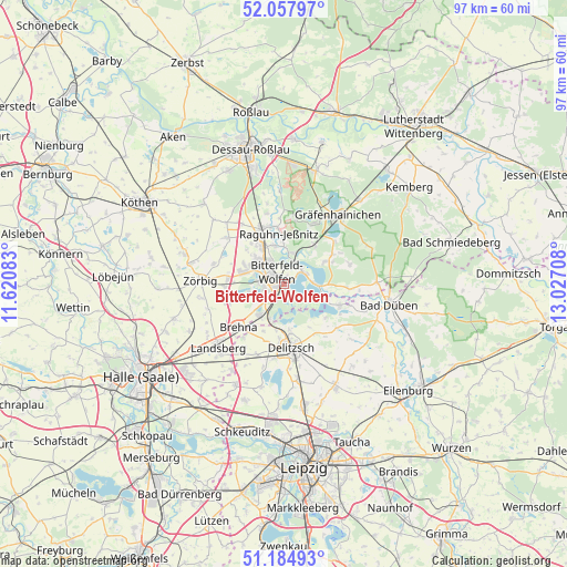
Bitterfeld-Wolfen GPS coordinates[2]
51° 37' 24.78" North, 12° 19' 26.22" East
| Map corner | latitude | longitude |
|---|---|---|
| Upper-left | 52.05797°, | 11.62083° |
| Center: | 51.62355°, | 12.32395° |
| Lower-right: | 51.18493°, | 13.02708° |
| Map W x H: | 97.1×97.1 km | = 60.3×60.3mi |
| max Lat: | 55.01917° ⇑32% North |
| Bitterfeld-Wolfen: | 51.62355° |
| min Lat: | ⇓68% South 47.40724° |
| min Long | Bitterfeld-Wolf | max Long |
| 5.92978° | 12.32395° | 14.98853° |
| W 86%⇐ | ⇒14% E |
Elevation
Elevation of Bitterfeld-Wolfen is 79 m = 259 ft, and this is 170.1 m = 558 ft below average elevation for this country.
| Max E: |
1256 m = 4121 ft | 71.8% |
| Avg. | 249.1 m = 817 ft | |
| Bitterfeld-Wolfen | 79 m = 259 ft | |
Min E: |
-5 m = -16 ft | 28.2% |
See also: Germany elevation on elevation.city.
Geographical zone
Bitterfeld-Wolfen is located in North temperate zone (between Tropic of Cancer and the Arctic Circle). Distance of this North polar circle is 1661.2 km =1032.2 mi to North.| Distance of | km | miles | from Bitterfeld-Wolfen |
|---|---|---|---|
| North Pole | 4267.1 | 2651.5 | to North |
| Arctic Circle | 1661.2 | 1032.2 | to North |
| Tropic Cancer | 3134.1 | 1947.4 | to South |
| Equator | 5740 | 3566.7 | to South |


Nearby cities:
15 places around Bitterfeld-Wolfen: (largest is in red/bold)
• Friedersdorf
4 km =2.5 mi,  46°
46°
• Greppin
3 km =1.9 mi,  328°
328°
• Holzweißig
3 km =1.9 mi,  200°
200°
• Jeßnitz
6.8 km =4.2 mi,  345°
345°
• Muldenstein
5.6 km =3.5 mi,  15°
15°
• Mühlbeck
4.3 km =2.7 mi,  66°
66°
• Petersroda
6.4 km =4 mi, 202°
• Pouch
5.3 km =3.3 mi,  90°
90°
• Ramsin
6.1 km =3.8 mi,  256°
256°
• Renneritz
7.2 km =4.5 mi,  250°
250°
• Roitzsch
6.8 km =4.2 mi,  217°
217°
• Sandersdorf
4.1 km =2.5 mi,  277°
277°
• Thalheim
7.4 km =4.6 mi,  295°
295°
• Wolfen
5.7 km =3.5 mi,  317°
317°
• Zscherndorf
4.1 km =2.5 mi, 250°
Sources, notices
• [Note1] Compared only with cities in Germany existing in our database
• [Src1] Map data: © OpenStreetMap contributors (CC-BY-SA)
• [Src2] Other city data from geonames.org with taken over terms of usage.
• [Src3] Geographical zone / Annual Mean Temperature by Robert A. Rohde @ Wikipedia
