Usedom geodata
Usedom (Mecklenburg-Vorpommern) is a populated place; located in Germany in Europe/Berlin (GMT+2) time zone. With population of 1,929 people, there are 5169 cities with bigger population in this country. Compared to other cities in Germany, 90.9% of cities are located further ↓South; 97.7% of cities are located further ←West and 99.5% of cities have higher elevation than Usedom. Note1
Administrative division(s):
- Level 1: Mecklenburg-Vorpommern
- Level 3: Vorpommern-Greifswald
- Level 4: Usedom


Usedom GPS coordinates[2]
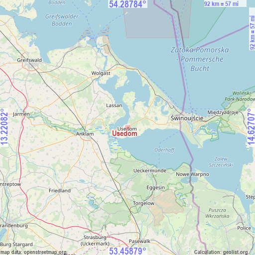
53° 52' 31.332" North, 13° 55' 26.184" East
| Map corner | latitude | longitude |
|---|---|---|
| Upper-left | 54.28784°, | 13.22082° |
| Center: | 53.87537°, | 13.92394° |
| Lower-right: | 53.45879°, | 14.62707° |
| Map W x H: | 92.2×92.2 km | = 57.3×57.3mi |
| max Lat: | 55.01917° ⇑9.1% North |
| Usedom: | 53.87537° |
| min Lat: | ⇓90.9% South 47.40724° |
| min Long | Usedom | max Long |
| 5.92978° | 13.92394° | 14.98853° |
| W 97.7%⇐ | ⇒2.3% E |
Elevation
Elevation of Usedom is -1 m = -3 ft, and this is 250.1 m = 821 ft below average elevation for this country.
| Max E: |
1256 m = 4121 ft | 99.5% |
| Avg. | 249.1 m = 817 ft | |
| Usedom | -1 m = -3 ft | |
Min E: |
-5 m = -16 ft | 0.5% |
See also: Germany elevation on elevation.city.
Geographical zone
Usedom is located in North temperate zone (between Tropic of Cancer and the Arctic Circle). Distance of this North polar circle is 1410.8 km =876.6 mi to North.| Distance of | km | miles | from Usedom |
|---|---|---|---|
| North Pole | 4016.7 | 2495.9 | to North |
| Arctic Circle | 1410.8 | 876.6 | to North |
| Tropic Cancer | 3384.5 | 2103 | to South |
| Equator | 5990.4 | 3722.3 | to South |


Nearby cities:
15 places around Usedom: (largest is in red/bold)
• Anklam
15.5 km =9.6 mi,  262°
262°
• Benz
12.1 km =7.5 mi,  53°
53°
• Dargen
9.4 km =5.8 mi,  81°
81°
• Ducherow
15.5 km =9.6 mi,  217°
217°
• Korswandt
16.3 km =10.1 mi,  72°
72°
• Lassan
9.4 km =5.8 mi,  330°
330°
• Leopoldshagen
11.4 km =7.1 mi,  190°
190°
• Murchin
12.5 km =7.8 mi,  286°
286°
• Mönkebude
12.3 km =7.6 mi,  166°
166°
• Neu Kosenow
14.5 km =9 mi,  231°
231°
• Rankwitz
7.8 km =4.8 mi,  1°
1°
• Rubkow
14.7 km =9.1 mi,  296°
296°
• Ueckermünde
17.2 km =10.7 mi,  152°
152°
• Zemitz
15.9 km =9.9 mi,  315°
315°
• Zirchow
14.2 km =8.8 mi, 83°
Sources, notices
• [Note1] Compared only with cities in Germany existing in our database
• [Src1] Map data: © OpenStreetMap contributors (CC-BY-SA)
• [Src2] Other city data from geonames.org with taken over terms of usage.
• [Src3] Geographical zone / Annual Mean Temperature by Robert A. Rohde @ Wikipedia
