Damlos geodata
Damlos (Schleswig-Holstein) is a seat of a fourth-order administrative division; located in Germany in Europe/Berlin (GMT+2) time zone. With population of 625 people, there are 8687 cities with bigger population in this country. Compared to other cities in Germany, 95.7% of cities are located further ↓South; 65.5% of cities are located further ←West and 91.6% of cities have higher elevation than Damlos. Note1


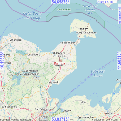
Damlos GPS coordinates[2]
54° 15' 0" North, 10° 54' 0" East
| Map corner | latitude | longitude |
|---|---|---|
| Upper-left | 54.65876°, | 10.19688° |
| Center: | 54.25°, | 10.9° |
| Lower-right: | 53.83715°, | 11.60313° |
| Map W x H: | 91.4×91.4 km | = 56.8×56.8mi |
| max Lat: | 55.01917° ⇑4.3% North |
| Damlos: | 54.25° |
| min Lat: | ⇓95.7% South 47.40724° |
| min Long | Damlos | max Long |
| 5.92978° | 10.9° | 14.98853° |
| W 65.5%⇐ | ⇒34.5% E |
Elevation
Elevation of Damlos is 17 m = 56 ft, and this is 232.1 m = 761 ft below average elevation for this country.
| Max E: |
1256 m = 4121 ft | 91.6% |
| Avg. | 249.1 m = 817 ft | |
| Damlos | 17 m = 56 ft | |
Min E: |
-5 m = -16 ft | 8.4% |
See also: Germany elevation on elevation.city.
Geographical zone
Damlos is located in North temperate zone (between Tropic of Cancer and the Arctic Circle). Distance of this North polar circle is 1369.1 km =850.7 mi to North.| Distance of | km | miles | from Damlos |
|---|---|---|---|
| North Pole | 3975 | 2469.9 | to North |
| Arctic Circle | 1369.1 | 850.7 | to North |
| Tropic Cancer | 3426.1 | 2128.9 | to South |
| Equator | 6032 | 3748.1 | to South |


Nearby cities:
15 places around Damlos: (largest is in red/bold)
• Beschendorf
7.7 km =4.8 mi,  196°
196°
• Goel
4.6 km =2.9 mi,  35°
35°
• Gremersdorf
9.5 km =5.9 mi,  13°
13°
• Grube
8.9 km =5.5 mi,  102°
102°
• Grömitz
11.9 km =7.4 mi,  158°
158°
• Harmsdorf
4.5 km =2.8 mi,  255°
255°
• Heringsdorf
8.9 km =5.5 mi,  50°
50°
• Kabelhorst
3.9 km =2.4 mi, 163°
• Kellenhusen
12.2 km =7.6 mi,  120°
120°
• Lensahn
3.9 km =2.4 mi, 196°
• Manhagen
5.7 km =3.5 mi,  168°
168°
• Neukirchen
11.1 km =6.9 mi, 42°
• Oldenburg in Holstein
5.1 km =3.2 mi,  1°
1°
• Riepsdorf
5.4 km =3.4 mi, 119°
• Wangels
8.9 km =5.5 mi,  282°
282°
Sources, notices
• [Note1] Compared only with cities in Germany existing in our database
• [Src1] Map data: © OpenStreetMap contributors (CC-BY-SA)
• [Src2] Other city data from geonames.org with taken over terms of usage.
• [Src3] Geographical zone / Annual Mean Temperature by Robert A. Rohde @ Wikipedia
