Heringsdorf geodata
Heringsdorf (Schleswig-Holstein) is a seat of a fourth-order administrative division; located in Germany in Europe/Berlin (GMT+2) time zone. With population of 1,103 people, there are 6837 cities with bigger population in this country. Compared to other cities in Germany, 96.3% of cities are located further ↓South; 67.1% of cities are located further ←West and 92.7% of cities have higher elevation than Heringsdorf. Note1
Administrative division(s):
- Level 1: Schleswig-Holstein
- Level 3: Kreis Ostholstein
- Level 4: Heringsdorf


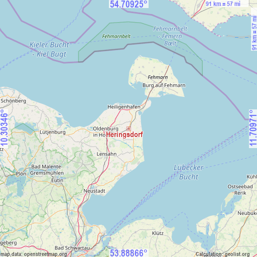
Heringsdorf GPS coordinates[2]
54° 18' 3.6" North, 11° 0' 23.688" East
| Map corner | latitude | longitude |
|---|---|---|
| Upper-left | 54.70925°, | 10.30346° |
| Center: | 54.301°, | 11.00658° |
| Lower-right: | 53.88866°, | 11.70971° |
| Map W x H: | 91.2×91.2 km | = 56.7×56.7mi |
| max Lat: | 55.01917° ⇑3.7% North |
| Heringsdorf: | 54.301° |
| min Lat: | ⇓96.3% South 47.40724° |
| min Long | Heringsdorf | max Long |
| 5.92978° | 11.00658° | 14.98853° |
| W 67.1%⇐ | ⇒32.9% E |
Elevation
Elevation of Heringsdorf is 14 m = 46 ft, and this is 235.1 m = 771 ft below average elevation for this country.
| Max E: |
1256 m = 4121 ft | 92.7% |
| Avg. | 249.1 m = 817 ft | |
| Heringsdorf | 14 m = 46 ft | |
Min E: |
-5 m = -16 ft | 7.3% |
See also: Germany elevation on elevation.city.
Geographical zone
Heringsdorf is located in North temperate zone (between Tropic of Cancer and the Arctic Circle). Distance of this North polar circle is 1363.5 km =847.2 mi to North.| Distance of | km | miles | from Heringsdorf |
|---|---|---|---|
| North Pole | 3969.4 | 2466.5 | to North |
| Arctic Circle | 1363.5 | 847.2 | to North |
| Tropic Cancer | 3431.8 | 2132.4 | to South |
| Equator | 6037.7 | 3751.7 | to South |


Nearby cities:
15 places around Heringsdorf: (largest is in red/bold)
• Dahme
10.6 km =6.6 mi,  152°
152°
• Damlos
8.9 km =5.5 mi,  230°
230°
• Goel
4.7 km =2.9 mi,  245°
245°
• Gremersdorf
6 km =3.7 mi,  307°
307°
• Grossenbrode
10.4 km =6.5 mi,  28°
28°
• Grube
7.7 km =4.8 mi,  167°
167°
• Harmsdorf
13.2 km =8.2 mi,  238°
238°
• Heiligenhafen
7.8 km =4.8 mi,  347°
347°
• Kabelhorst
11 km =6.8 mi,  211°
211°
• Kellenhusen
12.5 km =7.8 mi,  163°
163°
• Lensahn
12.3 km =7.6 mi,  220°
220°
• Manhagen
12.7 km =7.9 mi, 207°
• Neukirchen
2.6 km =1.6 mi,  11°
11°
• Oldenburg in Holstein
6.8 km =4.2 mi,  265°
265°
• Riepsdorf
8.6 km =5.3 mi,  194°
194°
Sources, notices
• [Note1] Compared only with cities in Germany existing in our database
• [Src1] Map data: © OpenStreetMap contributors (CC-BY-SA)
• [Src2] Other city data from geonames.org with taken over terms of usage.
• [Src3] Geographical zone / Annual Mean Temperature by Robert A. Rohde @ Wikipedia
