Dahlem geodata
Dahlem (North Rhine-Westphalia) is a seat of a fourth-order administrative division; located in Germany in Europe/Berlin (GMT+2) time zone. With population of 4,221 people, there are 3166 cities with bigger population in this country. Compared to other cities in Germany, 54.9% of cities are located further ↑North; 97.5% of cities are located further →East and 87.9% of cities have lower elevation than Dahlem. Note1
Administrative division(s):
- Level 1: North Rhine-Westphalia
- Level 2: Regierungsbezirk Köln
- Level 3: Kreis Euskirchen
- Level 4: Dahlem


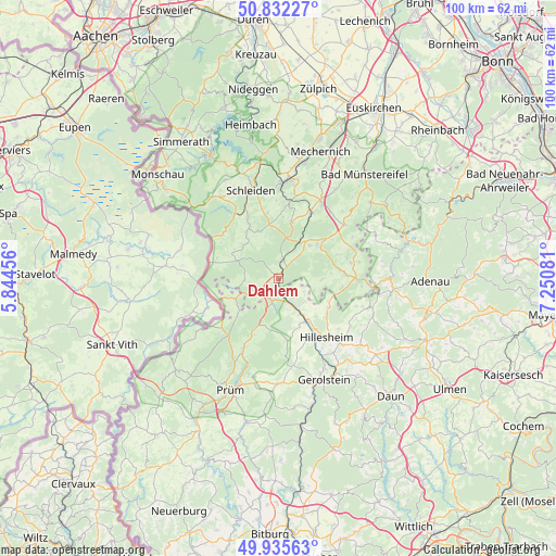
Dahlem GPS coordinates[2]
50° 23' 9.852" North, 6° 32' 51.648" East
| Map corner | latitude | longitude |
|---|---|---|
| Upper-left | 50.83227°, | 5.84456° |
| Center: | 50.38607°, | 6.54768° |
| Lower-right: | 49.93563°, | 7.25081° |
| Map W x H: | 99.7×99.7 km | = 62×62mi |
| max Lat: | 55.01917° ⇑54.9% North |
| Dahlem: | 50.38607° |
| min Lat: | ⇓45.1% South 47.40724° |
| min Long | Dahlem | max Long |
| 5.92978° | 6.54768° | 14.98853° |
| W 2.5%⇐ | ⇒97.5% E |
Elevation
Elevation of Dahlem is 493 m = 1617 ft, and this is 243.9 m = 800 ft above average elevation for this country.
| Max E: |
1256 m = 4121 ft | 12.1% |
| Dahlem | 493 m 1617 ft | |
| Avg. | 249.1 m = 817 ft | |
Min E: |
-5 m = -16 ft | 87.9% |
See also: Germany elevation on elevation.city.
Geographical zone
Dahlem is located in North temperate zone (between Tropic of Cancer and the Arctic Circle). Distance of this North polar circle is 1798.8 km =1117.7 mi to North.| Distance of | km | miles | from Dahlem |
|---|---|---|---|
| North Pole | 4404.7 | 2737 | to North |
| Arctic Circle | 1798.8 | 1117.7 | to North |
| Tropic Cancer | 2996.5 | 1861.9 | to South |
| Equator | 5602.4 | 3481.2 | to South |


Nearby cities:
15 places around Dahlem: (largest is in red/bold)
• Basberg
10.3 km =6.4 mi,  158°
158°
• Birgel
9.1 km =5.7 mi,  147°
147°
• Blankenheim
9 km =5.6 mi,  54°
54°
• Esch
5.3 km =3.3 mi,  113°
113°
• Feusdorf
6.3 km =3.9 mi,  129°
129°
• Gönnersdorf
6.9 km =4.3 mi, 147°
• Hallschlag
8.5 km =5.3 mi,  245°
245°
• Jünkerath
5.2 km =3.2 mi, 152°
• Kerschenbach
5.2 km =3.2 mi,  220°
220°
• Lissendorf
8.6 km =5.3 mi, 154°
• Ormont
10 km =6.2 mi,  228°
228°
• Scheid
9.4 km =5.8 mi, 251°
• Schüller
6.4 km =4 mi, 156°
• Stadtkyll
4.1 km =2.5 mi,  194°
194°
• Wiesbaum
10.2 km =6.3 mi,  119°
119°
Sources, notices
• [Note1] Compared only with cities in Germany existing in our database
• [Src1] Map data: © OpenStreetMap contributors (CC-BY-SA)
• [Src2] Other city data from geonames.org with taken over terms of usage.
• [Src3] Geographical zone / Annual Mean Temperature by Robert A. Rohde @ Wikipedia
