Ormont geodata
Ormont (Rheinland-Pfalz) is a seat of a fourth-order administrative division; located in Germany in Europe/Berlin (GMT+2) time zone. With population of 378 people, there are 9764 cities with bigger population in this country. Compared to other cities in Germany, 56.1% of cities are located further ↑North; 98.2% of cities are located further →East and 92.9% of cities have lower elevation than Ormont. Note1


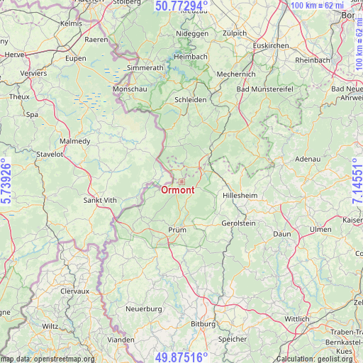
Ormont GPS coordinates[2]
50° 19' 34.212" North, 6° 26' 32.568" East
| Map corner | latitude | longitude |
|---|---|---|
| Upper-left | 50.77294°, | 5.73926° |
| Center: | 50.32617°, | 6.44238° |
| Lower-right: | 49.87516°, | 7.14551° |
| Map W x H: | 99.8×99.8 km | = 62×62mi |
| max Lat: | 55.01917° ⇑56.1% North |
| Ormont: | 50.32617° |
| min Lat: | ⇓43.9% South 47.40724° |
| min Long | Ormont | max Long |
| 5.92978° | 6.44238° | 14.98853° |
| W 1.8%⇐ | ⇒98.2% E |
Elevation
Elevation of Ormont is 556 m = 1824 ft, and this is 306.9 m = 1007 ft above average elevation for this country.
| Max E: |
1256 m = 4121 ft | 7.1% |
| Ormont | 556 m 1824 ft | |
| Avg. | 249.1 m = 817 ft | |
Min E: |
-5 m = -16 ft | 92.9% |
See also: Germany elevation on elevation.city.
Geographical zone
Ormont is located in North temperate zone (between Tropic of Cancer and the Arctic Circle). Distance of this North polar circle is 1805.4 km =1121.8 mi to North.| Distance of | km | miles | from Ormont |
|---|---|---|---|
| North Pole | 4411.3 | 2741.1 | to North |
| Arctic Circle | 1805.4 | 1121.8 | to North |
| Tropic Cancer | 2989.8 | 1857.8 | to South |
| Equator | 5595.7 | 3477 | to South |


Nearby cities:
15 places around Ormont: (largest is in red/bold)
• Auw
7.9 km =4.9 mi,  249°
249°
• Dahlem
10 km =6.2 mi,  48°
48°
• Gondenbrett
10.5 km =6.5 mi,  190°
190°
• Hallschlag
3.2 km =2 mi,  354°
354°
• Jünkerath
10.1 km =6.3 mi,  78°
78°
• Kerschenbach
4.9 km =3 mi,  57°
57°
• Kleinlangenfeld
7.2 km =4.5 mi,  156°
156°
• Neuendorf
5.1 km =3.2 mi, 160°
• Olzheim
6.1 km =3.8 mi,  171°
171°
• Reuth
4.1 km =2.5 mi,  135°
135°
• Scheid
3.9 km =2.4 mi,  338°
338°
• Schüller
10 km =6.2 mi,  85°
85°
• Stadtkyll
7 km =4.3 mi,  67°
67°
• Steffeln
10 km =6.2 mi,  118°
118°
• Weinsheim
10.5 km =6.5 mi, 170°
Sources, notices
• [Note1] Compared only with cities in Germany existing in our database
• [Src1] Map data: © OpenStreetMap contributors (CC-BY-SA)
• [Src2] Other city data from geonames.org with taken over terms of usage.
• [Src3] Geographical zone / Annual Mean Temperature by Robert A. Rohde @ Wikipedia
