Bunsoh geodata
Bunsoh (Schleswig-Holstein) is a seat of a fourth-order administrative division; located in Germany in Europe/Berlin (GMT+2) time zone. With population of 915 people, there are 7475 cities with bigger population in this country. Compared to other cities in Germany, 94.6% of cities are located further ↓South; 60.5% of cities are located further →East and 84.5% of cities have higher elevation than Bunsoh. Note1


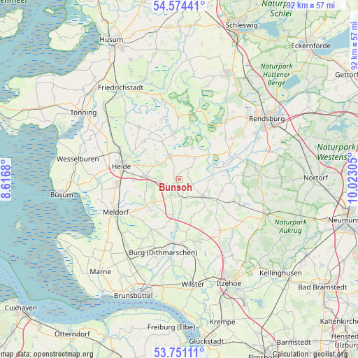
Bunsoh GPS coordinates[2]
54° 9' 53.316" North, 9° 19' 11.712" East
| Map corner | latitude | longitude |
|---|---|---|
| Upper-left | 54.57441°, | 8.6168° |
| Center: | 54.16481°, | 9.31992° |
| Lower-right: | 53.75111°, | 10.02305° |
| Map W x H: | 91.5×91.5 km | = 56.9×56.9mi |
| max Lat: | 55.01917° ⇑5.4% North |
| Bunsoh: | 54.16481° |
| min Lat: | ⇓94.6% South 47.40724° |
| min Long | Bunsoh | max Long |
| 5.92978° | 9.31992° | 14.98853° |
| W 39.5%⇐ | ⇒60.5% E |
Elevation
Elevation of Bunsoh is 36 m = 118 ft, and this is 213.1 m = 699 ft below average elevation for this country.
| Max E: |
1256 m = 4121 ft | 84.5% |
| Avg. | 249.1 m = 817 ft | |
| Bunsoh | 36 m = 118 ft | |
Min E: |
-5 m = -16 ft | 15.5% |
See also: Germany elevation on elevation.city.
Geographical zone
Bunsoh is located in North temperate zone (between Tropic of Cancer and the Arctic Circle). Distance of this North polar circle is 1378.6 km =856.6 mi to North.| Distance of | km | miles | from Bunsoh |
|---|---|---|---|
| North Pole | 3984.5 | 2475.9 | to North |
| Arctic Circle | 1378.6 | 856.6 | to North |
| Tropic Cancer | 3416.6 | 2123 | to South |
| Equator | 6022.6 | 3742.3 | to South |


Nearby cities:
15 places around Bunsoh: (largest is in red/bold)
• Albersdorf
2.9 km =1.8 mi,  235°
235°
• Arkebek
4.6 km =2.9 mi,  272°
272°
• Beldorf
4 km =2.5 mi,  150°
150°
• Gaushorn
6.9 km =4.3 mi,  304°
304°
• Hanerau-Hademarschen
7.2 km =4.5 mi,  119°
119°
• Immenstedt
2.4 km =1.5 mi,  327°
327°
• Offenbüttel
2.4 km =1.5 mi,  74°
74°
• Osterrade
4.4 km =2.7 mi,  26°
26°
• Schrum
5 km =3.1 mi,  294°
294°
• Steenfeld
3.5 km =2.2 mi, 118°
• Süderdorf
6.1 km =3.8 mi,  18°
18°
• Tellingstedt
6.2 km =3.9 mi,  337°
337°
• Welmbüttel
6 km =3.7 mi,  310°
310°
• Wennbüttel
3.6 km =2.2 mi,  165°
165°
• Wrohm
6.7 km =4.2 mi,  37°
37°
Sources, notices
• [Note1] Compared only with cities in Germany existing in our database
• [Src1] Map data: © OpenStreetMap contributors (CC-BY-SA)
• [Src2] Other city data from geonames.org with taken over terms of usage.
• [Src3] Geographical zone / Annual Mean Temperature by Robert A. Rohde @ Wikipedia
