Brockscheid geodata
Brockscheid (Rheinland-Pfalz) is a seat of a fourth-order administrative division; located in Germany in Europe/Berlin (GMT+2) time zone. With population of 216 people, there are 10403 cities with bigger population in this country. Compared to other cities in Germany, 60.7% of cities are located further ↑North; 95.1% of cities are located further →East and 84.3% of cities have lower elevation than Brockscheid. Note1


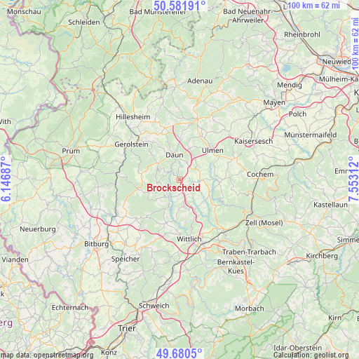
Brockscheid GPS coordinates[2]
50° 7' 59.988" North, 6° 51' 0" East
| Map corner | latitude | longitude |
|---|---|---|
| Upper-left | 50.58191°, | 6.14687° |
| Center: | 50.13333°, | 6.85° |
| Lower-right: | 49.6805°, | 7.55312° |
| Map W x H: | 100.2×100.2 km | = 62.3×62.3mi |
| max Lat: | 55.01917° ⇑60.7% North |
| Brockscheid: | 50.13333° |
| min Lat: | ⇓39.3% South 47.40724° |
| min Long | Brockscheid | max Long |
| 5.92978° | 6.85° | 14.98853° |
| W 4.9%⇐ | ⇒95.1% E |
Elevation
Elevation of Brockscheid is 463 m = 1519 ft, and this is 213.9 m = 702 ft above average elevation for this country.
| Max E: |
1256 m = 4121 ft | 15.7% |
| Brockscheid | 463 m 1519 ft | |
| Avg. | 249.1 m = 817 ft | |
Min E: |
-5 m = -16 ft | 84.3% |
See also: Germany elevation on elevation.city.
Geographical zone
Brockscheid is located in North temperate zone (between Tropic of Cancer and the Arctic Circle). Distance of this North polar circle is 1826.9 km =1135.2 mi to North.| Distance of | km | miles | from Brockscheid |
|---|---|---|---|
| North Pole | 4432.8 | 2754.4 | to North |
| Arctic Circle | 1826.9 | 1135.2 | to North |
| Tropic Cancer | 2968.4 | 1844.5 | to South |
| Equator | 5574.3 | 3463.7 | to South |


Nearby cities:
15 places around Brockscheid: (largest is in red/bold)
• Bleckhausen
4.8 km =3 mi,  270°
270°
• Dierfeld
6 km =3.7 mi,  156°
156°
• Eckfeld
1.9 km =1.2 mi,  180°
180°
• Ellscheid
5.1 km =3.2 mi,  68°
68°
• Gillenfeld
3.9 km =2.4 mi,  98°
98°
• Laufeld
5.7 km =3.5 mi,  167°
167°
• Manderscheid
5 km =3.1 mi,  215°
215°
• Mehren
6 km =3.7 mi,  23°
23°
• Pantenburg
5.7 km =3.5 mi,  192°
192°
• Saxler
3.6 km =2.2 mi,  90°
90°
• Schalkenmehren
3.6 km =2.2 mi,  12°
12°
• Strohn
5.1 km =3.2 mi,  111°
111°
• Udler
2.4 km =1.5 mi, 90°
• Wallscheid
4.4 km =2.7 mi,  147°
147°
• Üdersdorf
4 km =2.5 mi,  297°
297°
Sources, notices
• [Note1] Compared only with cities in Germany existing in our database
• [Src1] Map data: © OpenStreetMap contributors (CC-BY-SA)
• [Src2] Other city data from geonames.org with taken over terms of usage.
• [Src3] Geographical zone / Annual Mean Temperature by Robert A. Rohde @ Wikipedia
