Pantenburg geodata
Pantenburg (Rheinland-Pfalz) is a seat of a fourth-order administrative division; located in Germany in Europe/Berlin (GMT+2) time zone. With population of 253 people, there are 10248 cities with bigger population in this country. Compared to other cities in Germany, 61.8% of cities are located further ↑North; 95.3% of cities are located further →East and 76.2% of cities have lower elevation than Pantenburg. Note1
Administrative division(s):
- Level 1: Rheinland-Pfalz
- Level 3: Landkreis Bernkastel-Wittlich
- Level 4: Pantenburg


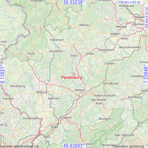
Pantenburg GPS coordinates[2]
50° 4' 59.988" North, 6° 49' 59.988" East
| Map corner | latitude | longitude |
|---|---|---|
| Upper-left | 50.53238°, | 6.13021° |
| Center: | 50.08333°, | 6.83333° |
| Lower-right: | 49.63003°, | 7.53646° |
| Map W x H: | 100.3×100.3 km | = 62.3×62.3mi |
| max Lat: | 55.01917° ⇑61.8% North |
| Pantenburg: | 50.08333° |
| min Lat: | ⇓38.2% South 47.40724° |
| min Long | Pantenburg | max Long |
| 5.92978° | 6.83333° | 14.98853° |
| W 4.7%⇐ | ⇒95.3% E |
Elevation
Elevation of Pantenburg is 407 m = 1335 ft, and this is 157.9 m = 518 ft above average elevation for this country.
| Max E: |
1256 m = 4121 ft | 23.8% |
| Pantenburg | 407 m 1335 ft | |
| Avg. | 249.1 m = 817 ft | |
Min E: |
-5 m = -16 ft | 76.2% |
See also: Germany elevation on elevation.city.
Geographical zone
Pantenburg is located in North temperate zone (between Tropic of Cancer and the Arctic Circle). Distance of this North polar circle is 1832.4 km =1138.6 mi to North.| Distance of | km | miles | from Pantenburg |
|---|---|---|---|
| North Pole | 4438.3 | 2757.8 | to North |
| Arctic Circle | 1832.4 | 1138.6 | to North |
| Tropic Cancer | 2962.8 | 1841 | to South |
| Equator | 5568.7 | 3460.2 | to South |


Nearby cities:
15 places around Pantenburg: (largest is in red/bold)
• Bettenfeld
5.2 km =3.2 mi,  272°
272°
• Brockscheid
5.7 km =3.5 mi,  12°
12°
• Dierfeld
3.6 km =2.2 mi,  90°
90°
• Eckfeld
3.9 km =2.4 mi,  17°
17°
• Gipperath
6 km =3.7 mi,  156°
156°
• Karl
4.4 km =2.7 mi,  212°
212°
• Laufeld
2.4 km =1.5 mi, 90°
• Manderscheid
2.2 km =1.4 mi,  311°
311°
• Meerfeld
5.6 km =3.5 mi,  282°
282°
• Mückeln
5.9 km =3.7 mi, 90°
• Niederöfflingen
4 km =2.5 mi,  117°
117°
• Oberöfflingen
3 km =1.9 mi,  127°
127°
• Plein
6 km =3.7 mi, 156°
• Schladt
5.6 km =3.5 mi,  180°
180°
• Wallscheid
4 km =2.5 mi,  62°
62°
Sources, notices
• [Note1] Compared only with cities in Germany existing in our database
• [Src1] Map data: © OpenStreetMap contributors (CC-BY-SA)
• [Src2] Other city data from geonames.org with taken over terms of usage.
• [Src3] Geographical zone / Annual Mean Temperature by Robert A. Rohde @ Wikipedia
