Bretsch geodata
Bretsch (Saxony-Anhalt) is a populated place; located in Germany in Europe/Berlin (GMT+2) time zone. With population of 674 people, there are 8455 cities with bigger population in this country. Compared to other cities in Germany, 80.7% of cities are located further ↓South; 76.2% of cities are located further ←West and 83.7% of cities have higher elevation than Bretsch. Note1
Administrative division(s):
- Level 1: Saxony-Anhalt
- Level 3: Landkreis Stendal
- Level 4: Altmärkische Höhe


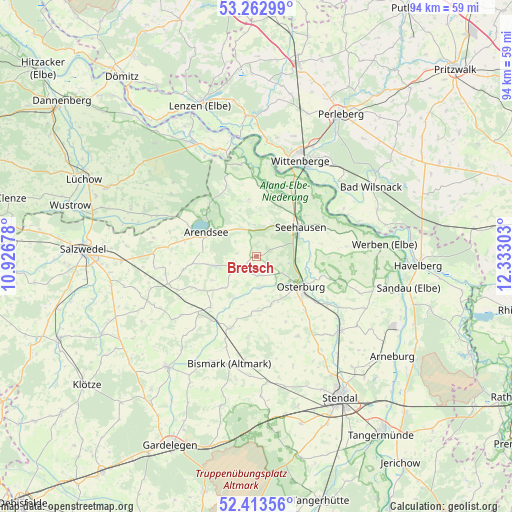
Bretsch GPS coordinates[2]
52° 50' 25.26" North, 11° 37' 47.64" East
| Map corner | latitude | longitude |
|---|---|---|
| Upper-left | 53.26299°, | 10.92678° |
| Center: | 52.84035°, | 11.6299° |
| Lower-right: | 52.41356°, | 12.33303° |
| Map W x H: | 94.4×94.4 km | = 58.7×58.7mi |
| max Lat: | 55.01917° ⇑19.3% North |
| Bretsch: | 52.84035° |
| min Lat: | ⇓80.7% South 47.40724° |
| min Long | Bretsch | max Long |
| 5.92978° | 11.6299° | 14.98853° |
| W 76.2%⇐ | ⇒23.8% E |
Elevation
Elevation of Bretsch is 38 m = 125 ft, and this is 211.1 m = 693 ft below average elevation for this country.
| Max E: |
1256 m = 4121 ft | 83.7% |
| Avg. | 249.1 m = 817 ft | |
| Bretsch | 38 m = 125 ft | |
Min E: |
-5 m = -16 ft | 16.3% |
See also: Germany elevation on elevation.city.
Geographical zone
Bretsch is located in North temperate zone (between Tropic of Cancer and the Arctic Circle). Distance of this North polar circle is 1525.9 km =948.2 mi to North.| Distance of | km | miles | from Bretsch |
|---|---|---|---|
| North Pole | 4131.8 | 2567.4 | to North |
| Arctic Circle | 1525.9 | 948.2 | to North |
| Tropic Cancer | 3269.4 | 2031.5 | to South |
| Equator | 5875.3 | 3650.7 | to South |


Nearby cities:
15 places around Bretsch: (largest is in red/bold)
• Beuster
15.2 km =9.4 mi,  43°
43°
• Brunau
14.9 km =9.3 mi,  226°
226°
• Erxleben
13.6 km =8.5 mi,  137°
137°
• Flessau
9.4 km =5.8 mi,  162°
162°
• Groß Garz
10.4 km =6.5 mi,  353°
353°
• Kleinau
9.2 km =5.7 mi,  240°
240°
• Krevese
5.3 km =3.3 mi,  126°
126°
• Krüden
10.3 km =6.4 mi,  26°
26°
• Königsmark
15.1 km =9.4 mi,  107°
107°
• Luftkurort Arendsee
10.6 km =6.6 mi,  294°
294°
• Lückstedt
3.5 km =2.2 mi, 232°
• Meßdorf
14.2 km =8.8 mi,  200°
200°
• Osterburg
10.2 km =6.3 mi, 125°
• Schönberg
13.8 km =8.6 mi,  71°
71°
• Seehausen
9.8 km =6.1 mi,  56°
56°
Sources, notices
• [Note1] Compared only with cities in Germany existing in our database
• [Src1] Map data: © OpenStreetMap contributors (CC-BY-SA)
• [Src2] Other city data from geonames.org with taken over terms of usage.
• [Src3] Geographical zone / Annual Mean Temperature by Robert A. Rohde @ Wikipedia
