Krevese geodata
Krevese (Saxony-Anhalt) is a populated place; located in Germany in Europe/Berlin (GMT+2) time zone. With population of 523 people, there are 9235 cities with bigger population in this country. Compared to other cities in Germany, 80.5% of cities are located further ↓South; 77.1% of cities are located further ←West and 84.1% of cities have higher elevation than Krevese. Note1
Administrative division(s):
- Level 1: Saxony-Anhalt
- Level 3: Landkreis Stendal
- Level 4: Osterburg (Altmark)


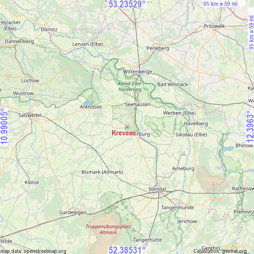
Krevese GPS coordinates[2]
52° 48' 44.568" North, 11° 41' 35.412" East
| Map corner | latitude | longitude |
|---|---|---|
| Upper-left | 53.23529°, | 10.99005° |
| Center: | 52.81238°, | 11.69317° |
| Lower-right: | 52.38531°, | 12.3963° |
| Map W x H: | 94.5×94.5 km | = 58.7×58.7mi |
| max Lat: | 55.01917° ⇑19.5% North |
| Krevese: | 52.81238° |
| min Lat: | ⇓80.5% South 47.40724° |
| min Long | Krevese | max Long |
| 5.92978° | 11.69317° | 14.98853° |
| W 77.1%⇐ | ⇒22.9% E |
Elevation
Elevation of Krevese is 37 m = 121 ft, and this is 212.1 m = 696 ft below average elevation for this country.
| Max E: |
1256 m = 4121 ft | 84.1% |
| Avg. | 249.1 m = 817 ft | |
| Krevese | 37 m = 121 ft | |
Min E: |
-5 m = -16 ft | 15.9% |
See also: Germany elevation on elevation.city.
Geographical zone
Krevese is located in North temperate zone (between Tropic of Cancer and the Arctic Circle). Distance of this North polar circle is 1529 km =950.1 mi to North.| Distance of | km | miles | from Krevese |
|---|---|---|---|
| North Pole | 4134.9 | 2569.3 | to North |
| Arctic Circle | 1529 | 950.1 | to North |
| Tropic Cancer | 3266.3 | 2029.6 | to South |
| Equator | 5872.2 | 3648.8 | to South |


Nearby cities:
15 places around Krevese: (largest is in red/bold)
• Beuster
15.5 km =9.6 mi,  23°
23°
• Bretsch
5.3 km =3.3 mi,  306°
306°
• Erxleben
8.5 km =5.3 mi,  144°
144°
• Flessau
6 km =3.7 mi,  194°
194°
• Groß Garz
14.5 km =9 mi,  337°
337°
• Iden
15.2 km =9.4 mi,  103°
103°
• Kleinau
12.3 km =7.6 mi,  263°
263°
• Krüden
12.3 km =7.6 mi,  1°
1°
• Königsmark
10.2 km =6.3 mi, 98°
• Lückstedt
7.1 km =4.4 mi,  277°
277°
• Meßdorf
13.7 km =8.5 mi,  221°
221°
• Osterburg
4.9 km =3 mi,  124°
124°
• Rochau
12.2 km =7.6 mi,  163°
163°
• Schönberg
11.6 km =7.2 mi,  49°
49°
• Seehausen
9.4 km =5.8 mi,  25°
25°
Sources, notices
• [Note1] Compared only with cities in Germany existing in our database
• [Src1] Map data: © OpenStreetMap contributors (CC-BY-SA)
• [Src2] Other city data from geonames.org with taken over terms of usage.
• [Src3] Geographical zone / Annual Mean Temperature by Robert A. Rohde @ Wikipedia
