Bous geodata
Bous (Saarland) is a seat of a fourth-order administrative division; located in Germany in Europe/Berlin (GMT+2) time zone. With population of 7,605 people, there are 2041 cities with bigger population in this country. Compared to other cities in Germany, 79.1% of cities are located further ↑North; 95.6% of cities are located further →East and 50.3% of cities have higher elevation than Bous. Note1


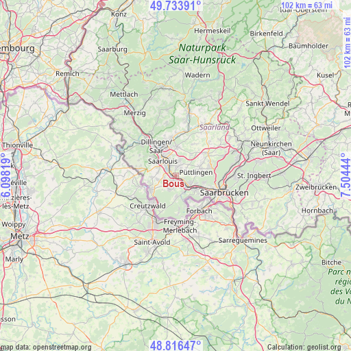
Bous GPS coordinates[2]
49° 16' 38.352" North, 6° 48' 4.716" East
| Map corner | latitude | longitude |
|---|---|---|
| Upper-left | 49.73391°, | 6.09819° |
| Center: | 49.27732°, | 6.80131° |
| Lower-right: | 48.81647°, | 7.50444° |
| Map W x H: | 102×102 km | = 63.4×63.4mi |
| max Lat: | 55.01917° ⇑79.1% North |
| Bous: | 49.27732° |
| min Lat: | ⇓20.9% South 47.40724° |
| min Long | Bous | max Long |
| 5.92978° | 6.80131° | 14.98853° |
| W 4.4%⇐ | ⇒95.6% E |
Elevation
Elevation of Bous is 223 m = 732 ft, and this is 26.1 m = 86 ft below average elevation for this country.
| Max E: |
1256 m = 4121 ft | 50.3% |
| Avg. | 249.1 m = 817 ft | |
| Bous | 223 m = 732 ft | |
Min E: |
-5 m = -16 ft | 49.7% |
See also: Germany elevation on elevation.city.
Geographical zone
Bous is located in North temperate zone (between Tropic of Cancer and the Arctic Circle). Distance of this North polar circle is 1922 km =1194.3 mi to North.| Distance of | km | miles | from Bous |
|---|---|---|---|
| North Pole | 4527.9 | 2813.5 | to North |
| Arctic Circle | 1922 | 1194.3 | to North |
| Tropic Cancer | 2873.2 | 1785.3 | to South |
| Equator | 5479.1 | 3404.6 | to South |


Nearby cities:
15 places around Bous: (largest is in red/bold)
• Altforweiler
6.9 km =4.3 mi,  267°
267°
• Bisten
7.3 km =4.5 mi,  249°
249°
• Ensdorf
2.8 km =1.7 mi,  332°
332°
• Fenne
6.9 km =4.3 mi,  119°
119°
• Fürstenhausen
6.3 km =3.9 mi,  129°
129°
• Heidstock
6.3 km =3.9 mi,  112°
112°
• Hostenbach
1.8 km =1.1 mi,  147°
147°
• Ludweiler-Warndt
6.3 km =3.9 mi,  173°
173°
• Püttlingen
6.3 km =3.9 mi,  81°
81°
• Röchling-Höhe
2.5 km =1.6 mi, 106°
• Saarlouis
5.4 km =3.4 mi,  318°
318°
• Schaffhausen
2.4 km =1.5 mi,  164°
164°
• Schwalbach
2.8 km =1.7 mi,  23°
23°
• Völklingen
5.1 km =3.2 mi, 124°
• Wadgassen
1.8 km =1.1 mi,  227°
227°
Sources, notices
• [Note1] Compared only with cities in Germany existing in our database
• [Src1] Map data: © OpenStreetMap contributors (CC-BY-SA)
• [Src2] Other city data from geonames.org with taken over terms of usage.
• [Src3] Geographical zone / Annual Mean Temperature by Robert A. Rohde @ Wikipedia
