Bornheim geodata
Bornheim (Rheinland-Pfalz) is a seat of a fourth-order administrative division; located in Germany in Europe/Berlin (GMT+2) time zone. With population of 700 people, there are 8312 cities with bigger population in this country. Compared to other cities in Germany, 69.4% of cities are located further ↑North; 76.1% of cities are located further →East and 60.1% of cities have higher elevation than Bornheim. Note1
Administrative division(s):
- Level 1: Rheinland-Pfalz
- Level 3: Landkreis Alzey-Worms
- Level 4: Bornheim


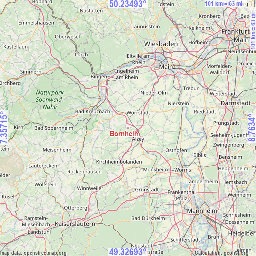
Bornheim GPS coordinates[2]
49° 46' 59.016" North, 8° 3' 37.008" East
| Map corner | latitude | longitude |
|---|---|---|
| Upper-left | 50.23493°, | 7.35715° |
| Center: | 49.78306°, | 8.06028° |
| Lower-right: | 49.32693°, | 8.7634° |
| Map W x H: | 101×101 km | = 62.8×62.8mi |
| max Lat: | 55.01917° ⇑69.4% North |
| Bornheim: | 49.78306° |
| min Lat: | ⇓30.6% South 47.40724° |
| min Long | Bornheim | max Long |
| 5.92978° | 8.06028° | 14.98853° |
| W 23.9%⇐ | ⇒76.1% E |
Elevation
Elevation of Bornheim is 151 m = 495 ft, and this is 98.1 m = 322 ft below average elevation for this country.
| Max E: |
1256 m = 4121 ft | 60.1% |
| Avg. | 249.1 m = 817 ft | |
| Bornheim | 151 m = 495 ft | |
Min E: |
-5 m = -16 ft | 39.9% |
See also: Germany elevation on elevation.city.
Geographical zone
Bornheim is located in North temperate zone (between Tropic of Cancer and the Arctic Circle). Distance of this North polar circle is 1865.8 km =1159.4 mi to North.| Distance of | km | miles | from Bornheim |
|---|---|---|---|
| North Pole | 4471.7 | 2778.6 | to North |
| Arctic Circle | 1865.8 | 1159.4 | to North |
| Tropic Cancer | 2929.4 | 1820.2 | to South |
| Equator | 5535.4 | 3439.5 | to South |


Nearby cities:
15 places around Bornheim: (largest is in red/bold)
• Albig
4.5 km =2.8 mi,  103°
103°
• Alzey
5.7 km =3.5 mi,  135°
135°
• Armsheim
3 km =1.9 mi,  355°
355°
• Eckelsheim
5.8 km =3.6 mi,  288°
288°
• Ensheim
4.7 km =2.9 mi,  56°
56°
• Erbes-Büdesheim
3.8 km =2.4 mi,  213°
213°
• Flonheim
1.5 km =0.9 mi,  278°
278°
• Gau-Bickelheim
6.5 km =4 mi,  333°
333°
• Lonsheim
1.3 km =0.8 mi,  112°
112°
• Nack
5.8 km =3.6 mi,  225°
225°
• Offenheim
6.7 km =4.2 mi,  198°
198°
• Spiesheim
5.7 km =3.5 mi, 57°
• Wallertheim
5.9 km =3.7 mi,  353°
353°
• Wendelsheim
4.7 km =2.9 mi,  247°
247°
• Wonsheim
6.7 km =4.2 mi,  270°
270°
Sources, notices
• [Note1] Compared only with cities in Germany existing in our database
• [Src1] Map data: © OpenStreetMap contributors (CC-BY-SA)
• [Src2] Other city data from geonames.org with taken over terms of usage.
• [Src3] Geographical zone / Annual Mean Temperature by Robert A. Rohde @ Wikipedia
