Bodnegg geodata
Bodnegg (Baden-Württemberg) is a seat of a fourth-order administrative division; located in Germany in Europe/Berlin (GMT+2) time zone. With population of 3,136 people, there are 3881 cities with bigger population in this country. Compared to other cities in Germany, 98.7% of cities are located further ↑North; 54.5% of cities are located further →East and 95.1% of cities have lower elevation than Bodnegg. Note1
Administrative division(s):
- Level 1: Baden-Württemberg
- Level 2: Tübingen Region
- Level 3: Landkreis Ravensburg
- Level 4: Bodnegg


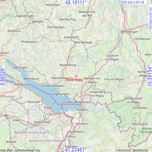
Bodnegg GPS coordinates[2]
47° 42' 36.504" North, 9° 41' 18.276" East
| Map corner | latitude | longitude |
|---|---|---|
| Upper-left | 48.18111°, | 8.98528° |
| Center: | 47.71014°, | 9.68841° |
| Lower-right: | 47.23487°, | 10.39154° |
| Map W x H: | 105.2×105.2 km | = 65.4×65.4mi |
| max Lat: | 55.01917° ⇑98.7% North |
| Bodnegg: | 47.71014° |
| min Lat: | ⇓1.3% South 47.40724° |
| min Long | Bodnegg | max Long |
| 5.92978° | 9.68841° | 14.98853° |
| W 45.5%⇐ | ⇒54.5% E |
Elevation
Elevation of Bodnegg is 601 m = 1972 ft, and this is 351.9 m = 1155 ft above average elevation for this country.
| Max E: |
1256 m = 4121 ft | 4.9% |
| Bodnegg | 601 m 1972 ft | |
| Avg. | 249.1 m = 817 ft | |
Min E: |
-5 m = -16 ft | 95.1% |
See also: Germany elevation on elevation.city.
Geographical zone
Bodnegg is located in North temperate zone (between Tropic of Cancer and the Arctic Circle). Distance of this North polar circle is 2096.3 km =1302.6 mi to North.| Distance of | km | miles | from Bodnegg |
|---|---|---|---|
| North Pole | 4702.2 | 2921.8 | to North |
| Arctic Circle | 2096.3 | 1302.6 | to North |
| Tropic Cancer | 2699 | 1677.1 | to South |
| Equator | 5304.9 | 3296.3 | to South |


Nearby cities:
15 places around Bodnegg: (largest is in red/bold)
• Amtzell
4.7 km =2.9 mi,  103°
103°
• Baienfurt
13.5 km =8.4 mi,  348°
348°
• Grünkraut
4.5 km =2.8 mi,  327°
327°
• Hergatz
12.7 km =7.9 mi,  121°
121°
• Hergensweiler
12.6 km =7.8 mi,  145°
145°
• Meckenbeuren
9.2 km =5.7 mi,  262°
262°
• Neukirch
6 km =3.7 mi,  169°
169°
• Niederwangen
9.3 km =5.8 mi, 117°
• Ravensburg
9.9 km =6.2 mi,  323°
323°
• Schlier
6.8 km =4.2 mi, 350°
• Tettnang
8.6 km =5.3 mi,  237°
237°
• Vogt
8.6 km =5.3 mi,  42°
42°
• Waldburg
5.5 km =3.4 mi,  19°
19°
• Wangen
11 km =6.8 mi, 102°
• Weingarten
11.7 km =7.3 mi,  341°
341°
Sources, notices
• [Note1] Compared only with cities in Germany existing in our database
• [Src1] Map data: © OpenStreetMap contributors (CC-BY-SA)
• [Src2] Other city data from geonames.org with taken over terms of usage.
• [Src3] Geographical zone / Annual Mean Temperature by Robert A. Rohde @ Wikipedia
