Bodenwöhr geodata
Bodenwöhr (Bavaria) is a seat of a fourth-order administrative division; located in Germany in Europe/Berlin (GMT+2) time zone. With population of 4,025 people, there are 3287 cities with bigger population in this country. Compared to other cities in Germany, 79.1% of cities are located further ↑North; 85.8% of cities are located further ←West and 74.1% of cities have lower elevation than Bodenwöhr. Note1
Administrative division(s):
- Level 1: Bavaria
- Level 2: Upper Palatinate
- Level 3: Landkreis Schwandorf
- Level 4: Bodenwöhr


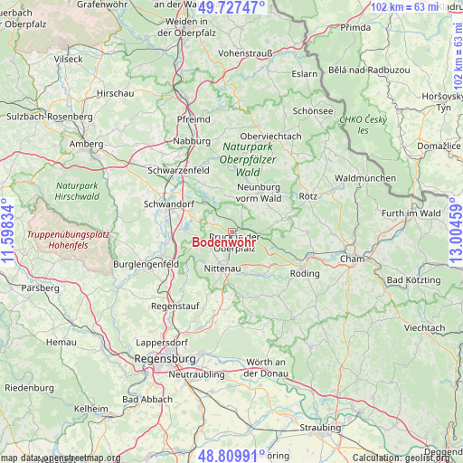
Bodenwöhr GPS coordinates[2]
49° 16' 14.952" North, 12° 18' 5.256" East
| Map corner | latitude | longitude |
|---|---|---|
| Upper-left | 49.72747°, | 11.59834° |
| Center: | 49.27082°, | 12.30146° |
| Lower-right: | 48.80991°, | 13.00459° |
| Map W x H: | 102×102 km | = 63.4×63.4mi |
| max Lat: | 55.01917° ⇑79.1% North |
| Bodenwöhr: | 49.27082° |
| min Lat: | ⇓20.9% South 47.40724° |
| min Long | Bodenwöhr | max Long |
| 5.92978° | 12.30146° | 14.98853° |
| W 85.8%⇐ | ⇒14.2% E |
Elevation
Elevation of Bodenwöhr is 390 m = 1280 ft, and this is 140.9 m = 462 ft above average elevation for this country.
| Max E: |
1256 m = 4121 ft | 25.9% |
| Bodenwöhr | 390 m 1280 ft | |
| Avg. | 249.1 m = 817 ft | |
Min E: |
-5 m = -16 ft | 74.1% |
See also: Germany elevation on elevation.city.
Geographical zone
Bodenwöhr is located in North temperate zone (between Tropic of Cancer and the Arctic Circle). Distance of this North polar circle is 1922.8 km =1194.8 mi to North.| Distance of | km | miles | from Bodenwöhr |
|---|---|---|---|
| North Pole | 4528.7 | 2814 | to North |
| Arctic Circle | 1922.8 | 1194.8 | to North |
| Tropic Cancer | 2872.5 | 1784.9 | to South |
| Equator | 5478.4 | 3404.1 | to South |


Nearby cities:
15 places around Bodenwöhr: (largest is in red/bold)
• Altendorf
15 km =9.3 mi,  354°
354°
• Bruck in der Oberpfalz
2.4 km =1.5 mi,  170°
170°
• Brunn
8.9 km =5.5 mi,  244°
244°
• Holzheim bei Oder
9.8 km =6.1 mi,  267°
267°
• Neukirchen-Balbini
10 km =6.2 mi,  77°
77°
• Neunburg vorm Wald
10.5 km =6.5 mi,  35°
35°
• Nittenau
8.9 km =5.5 mi,  196°
196°
• Pettendorf
10.2 km =6.3 mi,  24°
24°
• Reichenbach
10.3 km =6.4 mi,  160°
160°
• Schwarzhofen
12.3 km =7.6 mi,  14°
14°
• Steinberg
8.7 km =5.4 mi,  279°
279°
• Tiefenbach
9.6 km =6 mi, 170°
• Wackersdorf
10 km =6.2 mi,  300°
300°
• Wald
13.9 km =8.6 mi, 165°
• Walderbach
11.4 km =7.1 mi,  148°
148°
Sources, notices
• [Note1] Compared only with cities in Germany existing in our database
• [Src1] Map data: © OpenStreetMap contributors (CC-BY-SA)
• [Src2] Other city data from geonames.org with taken over terms of usage.
• [Src3] Geographical zone / Annual Mean Temperature by Robert A. Rohde @ Wikipedia
