Neunburg vorm Wald geodata
Neunburg vorm Wald (Bavaria) is a populated place; located in Germany in Europe/Berlin (GMT+2) time zone. With population of 8,172 people, there are 1932 cities with bigger population in this country. Compared to other cities in Germany, 78% of cities are located further ↑North; 86.9% of cities are located further ←West and 74.1% of cities have lower elevation than Neunburg vorm Wald. Note1
Administrative division(s):
- Level 1: Bavaria
- Level 2: Upper Palatinate
- Level 3: Landkreis Schwandorf
- Level 4: Neunburg vorm Wald


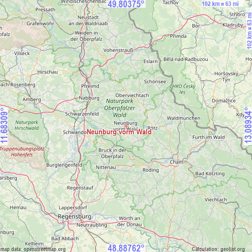
Neunburg vorm Wald GPS coordinates[2]
49° 20' 52.152" North, 12° 23' 10.356" East
| Map corner | latitude | longitude |
|---|---|---|
| Upper-left | 49.80375°, | 11.68309° |
| Center: | 49.34782°, | 12.38621° |
| Lower-right: | 48.88762°, | 13.08934° |
| Map W x H: | 101.9×101.9 km | = 63.3×63.3mi |
| max Lat: | 55.01917° ⇑78% North |
| Neunburg vorm Wald: | 49.34782° |
| min Lat: | ⇓22% South 47.40724° |
| min Long | Neunburg vorm W | max Long |
| 5.92978° | 12.38621° | 14.98853° |
| W 86.9%⇐ | ⇒13.1% E |
Elevation
Elevation of Neunburg vorm Wald is 390 m = 1280 ft, and this is 140.9 m = 462 ft above average elevation for this country.
| Max E: |
1256 m = 4121 ft | 25.9% |
| Neunburg vorm Wald | 390 m 1280 ft | |
| Avg. | 249.1 m = 817 ft | |
Min E: |
-5 m = -16 ft | 74.1% |
See also: Germany elevation on elevation.city.
Geographical zone
Neunburg vorm Wald is located in North temperate zone (between Tropic of Cancer and the Arctic Circle). Distance of this North polar circle is 1914.2 km =1189.4 mi to North.| Distance of | km | miles | from Neunburg vorm Wald |
|---|---|---|---|
| North Pole | 4520.1 | 2808.7 | to North |
| Arctic Circle | 1914.2 | 1189.4 | to North |
| Tropic Cancer | 2881 | 1790.2 | to South |
| Equator | 5487 | 3409.5 | to South |


Nearby cities:
15 places around Neunburg vorm Wald: (largest is in red/bold)
• Altendorf
9.9 km =6.2 mi,  310°
310°
• Bach
5.8 km =3.6 mi,  357°
357°
• Bodenwöhr
10.5 km =6.5 mi,  215°
215°
• Bruck in der Oberpfalz
12.4 km =7.7 mi,  207°
207°
• Dieterskirchen
8 km =5 mi,  16°
16°
• Guteneck
13.6 km =8.5 mi,  326°
326°
• Neukirchen-Balbini
7.3 km =4.5 mi,  150°
150°
• Niedermurach
11.4 km =7.1 mi, 356°
• Oberviechtach
12.5 km =7.8 mi,  10°
10°
• Pettendorf
2.1 km =1.3 mi,  291°
291°
• Rötz
10.4 km =6.5 mi,  92°
92°
• Schwarzhofen
4.5 km =2.8 mi,  317°
317°
• Stamsried
13.8 km =8.6 mi,  130°
130°
• Thanstein
7 km =4.3 mi,  55°
55°
• Winklarn
11.1 km =6.9 mi,  37°
37°
Sources, notices
• [Note1] Compared only with cities in Germany existing in our database
• [Src1] Map data: © OpenStreetMap contributors (CC-BY-SA)
• [Src2] Other city data from geonames.org with taken over terms of usage.
• [Src3] Geographical zone / Annual Mean Temperature by Robert A. Rohde @ Wikipedia
