Blankenhagen geodata
Blankenhagen (Mecklenburg-Vorpommern) is a populated place; located in Germany in Europe/Berlin (GMT+2) time zone. With population of 898 people, there are 7531 cities with bigger population in this country. Compared to other cities in Germany, 94.8% of cities are located further ↓South; 86.3% of cities are located further ←West and 85.4% of cities have higher elevation than Blankenhagen. Note1
Administrative division(s):
- Level 1: Mecklenburg-Vorpommern
- Level 3: Landkreis Rostock
- Level 4: Blankenhagen


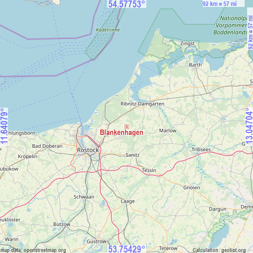
Blankenhagen GPS coordinates[2]
54° 10' 4.656" North, 12° 20' 38.076" East
| Map corner | latitude | longitude |
|---|---|---|
| Upper-left | 54.57753°, | 11.64079° |
| Center: | 54.16796°, | 12.34391° |
| Lower-right: | 53.75429°, | 13.04704° |
| Map W x H: | 91.5×91.5 km | = 56.9×56.9mi |
| max Lat: | 55.01917° ⇑5.2% North |
| Blankenhagen: | 54.16796° |
| min Lat: | ⇓94.8% South 47.40724° |
| min Long | Blankenhagen | max Long |
| 5.92978° | 12.34391° | 14.98853° |
| W 86.3%⇐ | ⇒13.7% E |
Elevation
Elevation of Blankenhagen is 34 m = 112 ft, and this is 215.1 m = 706 ft below average elevation for this country.
| Max E: |
1256 m = 4121 ft | 85.4% |
| Avg. | 249.1 m = 817 ft | |
| Blankenhagen | 34 m = 112 ft | |
Min E: |
-5 m = -16 ft | 14.6% |
See also: Germany elevation on elevation.city.
Geographical zone
Blankenhagen is located in North temperate zone (between Tropic of Cancer and the Arctic Circle). Distance of this North polar circle is 1378.3 km =856.4 mi to North.| Distance of | km | miles | from Blankenhagen |
|---|---|---|---|
| North Pole | 3984.1 | 2475.6 | to North |
| Arctic Circle | 1378.3 | 856.4 | to North |
| Tropic Cancer | 3417 | 2123.2 | to South |
| Equator | 6022.9 | 3742.5 | to South |


Nearby cities:
15 places around Blankenhagen: (largest is in red/bold)
• Bentwisch
10.8 km =6.7 mi,  237°
237°
• Broderstorf
11 km =6.8 mi,  208°
208°
• Dierkow-Neu
13.4 km =8.3 mi, 238°
• Dierkow-West
14.4 km =8.9 mi, 241°
• Gelbensande
4.7 km =2.9 mi,  324°
324°
• Klein Kussewitz
7.6 km =4.7 mi, 239°
• Marlow
15 km =9.3 mi,  95°
95°
• Mönchhagen
8.5 km =5.3 mi,  257°
257°
• Nienhagen
11.2 km =7 mi, 259°
• Ostseebad Dierhagen
13.9 km =8.6 mi,  3°
3°
• Ribnitz-Damgarten
11 km =6.8 mi,  41°
41°
• Roggentin
14.1 km =8.8 mi,  220°
220°
• Rövershagen
6.7 km =4.2 mi,  278°
278°
• Seeheilbad Graal-Müritz
11 km =6.8 mi,  326°
326°
• Thulendorf
8.6 km =5.3 mi,  198°
198°
Sources, notices
• [Note1] Compared only with cities in Germany existing in our database
• [Src1] Map data: © OpenStreetMap contributors (CC-BY-SA)
• [Src2] Other city data from geonames.org with taken over terms of usage.
• [Src3] Geographical zone / Annual Mean Temperature by Robert A. Rohde @ Wikipedia
