Ribnitz-Damgarten geodata
Ribnitz-Damgarten (Mecklenburg-Vorpommern) is a populated place; located in Germany in Europe/Berlin (GMT+2) time zone. With population of 17,152 people, there are 930 cities with bigger population in this country. Compared to other cities in Germany, 95.7% of cities are located further ↓South; 87.6% of cities are located further ←West and 96.2% of cities have higher elevation than Ribnitz-Damgarten. Note1
Administrative division(s):
- Level 1: Mecklenburg-Vorpommern
- Level 3: Vorpommern-Rügen
- Level 4: Ribnitz-Damgarten


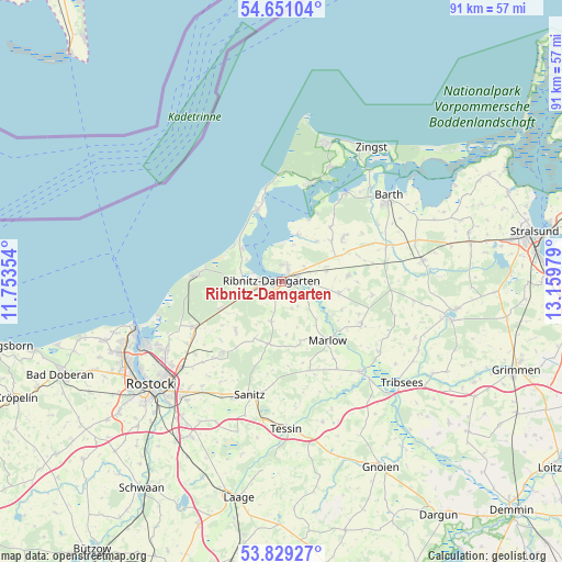
Ribnitz-Damgarten GPS coordinates[2]
54° 14' 31.92" North, 12° 27' 23.976" East
| Map corner | latitude | longitude |
|---|---|---|
| Upper-left | 54.65104°, | 11.75354° |
| Center: | 54.2422°, | 12.45666° |
| Lower-right: | 53.82927°, | 13.15979° |
| Map W x H: | 91.4×91.4 km | = 56.8×56.8mi |
| max Lat: | 55.01917° ⇑4.3% North |
| Ribnitz-Damgarten: | 54.2422° |
| min Lat: | ⇓95.7% South 47.40724° |
| min Long | Ribnitz-Damgart | max Long |
| 5.92978° | 12.45666° | 14.98853° |
| W 87.6%⇐ | ⇒12.4% E |
Elevation
Elevation of Ribnitz-Damgarten is 6 m = 20 ft, and this is 243.1 m = 798 ft below average elevation for this country.
| Max E: |
1256 m = 4121 ft | 96.2% |
| Avg. | 249.1 m = 817 ft | |
| Ribnitz-Damgarten | 6 m = 20 ft | |
Min E: |
-5 m = -16 ft | 3.8% |
See also: Germany elevation on elevation.city.
Geographical zone
Ribnitz-Damgarten is located in North temperate zone (between Tropic of Cancer and the Arctic Circle). Distance of this North polar circle is 1370 km =851.3 mi to North.| Distance of | km | miles | from Ribnitz-Damgarten |
|---|---|---|---|
| North Pole | 3975.9 | 2470.5 | to North |
| Arctic Circle | 1370 | 851.3 | to North |
| Tropic Cancer | 3425.2 | 2128.3 | to South |
| Equator | 6031.2 | 3747.6 | to South |


Nearby cities:
15 places around Ribnitz-Damgarten: (largest is in red/bold)
• Blankenhagen
11 km =6.8 mi,  221°
221°
• Born
16.6 km =10.3 mi,  16°
16°
• Fuhlendorf
16.2 km =10.1 mi,  35°
35°
• Gelbensande
11 km =6.8 mi,  246°
246°
• Klein Kussewitz
18.4 km =11.4 mi,  229°
229°
• Löbnitz
18 km =11.2 mi,  70°
70°
• Marlow
12.3 km =7.6 mi,  142°
142°
• Mönchhagen
18.6 km =11.6 mi,  237°
237°
• Ostseebad Ahrenshoop
15.8 km =9.8 mi,  352°
352°
• Ostseebad Dierhagen
8.5 km =5.3 mi,  311°
311°
• Rövershagen
15.7 km =9.8 mi, 242°
• Saal
8.1 km =5 mi, 20°
• Seeheilbad Graal-Müritz
13.4 km =8.3 mi,  274°
274°
• Semlow
14.7 km =9.1 mi,  117°
117°
• Trinwillershagen
10.9 km =6.8 mi,  85°
85°
Sources, notices
• [Note1] Compared only with cities in Germany existing in our database
• [Src1] Map data: © OpenStreetMap contributors (CC-BY-SA)
• [Src2] Other city data from geonames.org with taken over terms of usage.
• [Src3] Geographical zone / Annual Mean Temperature by Robert A. Rohde @ Wikipedia
