Bissee geodata
Bissee (Schleswig-Holstein) is a seat of a fourth-order administrative division; located in Germany in Europe/Berlin (GMT+2) time zone. With population of 185 people, there are 10539 cities with bigger population in this country. Compared to other cities in Germany, 94.9% of cities are located further ↓South; 51.9% of cities are located further ←West and 86.3% of cities have higher elevation than Bissee. Note1
Administrative division(s):
- Level 1: Schleswig-Holstein
- Level 3: Kreis Rendsburg-Eckernförde
- Level 4: Bissee


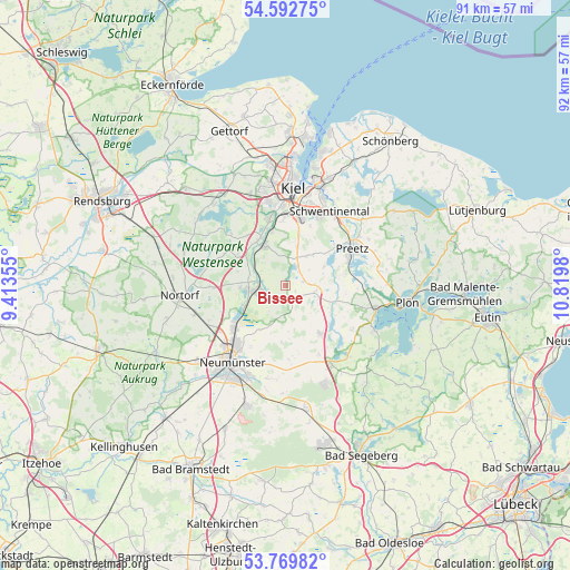
Bissee GPS coordinates[2]
54° 10' 59.988" North, 10° 7' 0.012" East
| Map corner | latitude | longitude |
|---|---|---|
| Upper-left | 54.59275°, | 9.41355° |
| Center: | 54.18333°, | 10.11667° |
| Lower-right: | 53.76982°, | 10.8198° |
| Map W x H: | 91.5×91.5 km | = 56.9×56.9mi |
| max Lat: | 55.01917° ⇑5.1% North |
| Bissee: | 54.18333° |
| min Lat: | ⇓94.9% South 47.40724° |
| min Long | Bissee | max Long |
| 5.92978° | 10.11667° | 14.98853° |
| W 51.9%⇐ | ⇒48.1% E |
Elevation
Elevation of Bissee is 32 m = 105 ft, and this is 217.1 m = 712 ft below average elevation for this country.
| Max E: |
1256 m = 4121 ft | 86.3% |
| Avg. | 249.1 m = 817 ft | |
| Bissee | 32 m = 105 ft | |
Min E: |
-5 m = -16 ft | 13.7% |
See also: Germany elevation on elevation.city.
Geographical zone
Bissee is located in North temperate zone (between Tropic of Cancer and the Arctic Circle). Distance of this North polar circle is 1376.6 km =855.4 mi to North.| Distance of | km | miles | from Bissee |
|---|---|---|---|
| North Pole | 3982.4 | 2474.5 | to North |
| Arctic Circle | 1376.6 | 855.4 | to North |
| Tropic Cancer | 3418.7 | 2124.3 | to South |
| Equator | 6024.6 | 3743.5 | to South |


Nearby cities:
15 places around Bissee: (largest is in red/bold)
• Barmissen
4.7 km =2.9 mi,  66°
66°
• Boksee
5.7 km =3.5 mi,  11°
11°
• Bordesholm
5.6 km =3.5 mi,  261°
261°
• Bothkamp
2.1 km =1.3 mi,  30°
30°
• Brügge
3.2 km =2 mi,  254°
254°
• Böhnhusen
4.9 km =3 mi,  318°
318°
• Groß Buchwald
2.9 km =1.8 mi,  229°
229°
• Kirchbarkau
3.6 km =2.2 mi, 30°
• Klein Barkau
5.7 km =3.5 mi, 11°
• Negenharrie
5.3 km =3.3 mi,  211°
211°
• Nettelsee
5 km =3.1 mi,  98°
98°
• Reesdorf
4.3 km =2.7 mi,  270°
270°
• Schmalstede
5.7 km =3.5 mi,  288°
288°
• Warnau
3.3 km =2.1 mi,  90°
90°
• Wattenbek
4.7 km =2.9 mi, 246°
Sources, notices
• [Note1] Compared only with cities in Germany existing in our database
• [Src1] Map data: © OpenStreetMap contributors (CC-BY-SA)
• [Src2] Other city data from geonames.org with taken over terms of usage.
• [Src3] Geographical zone / Annual Mean Temperature by Robert A. Rohde @ Wikipedia
