Nettelsee geodata
Nettelsee (Schleswig-Holstein) is a seat of a fourth-order administrative division; located in Germany in Europe/Berlin (GMT+2) time zone. With population of 394 people, there are 9711 cities with bigger population in this country. Compared to other cities in Germany, 94.8% of cities are located further ↓South; 53.2% of cities are located further ←West and 84.5% of cities have higher elevation than Nettelsee. Note1


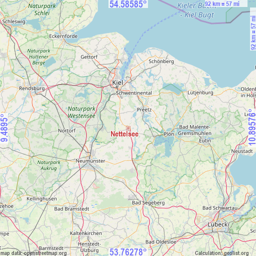
Nettelsee GPS coordinates[2]
54° 10' 34.896" North, 10° 11' 33.468" East
| Map corner | latitude | longitude |
|---|---|---|
| Upper-left | 54.58585°, | 9.4895° |
| Center: | 54.17636°, | 10.19263° |
| Lower-right: | 53.76278°, | 10.89576° |
| Map W x H: | 91.5×91.5 km | = 56.9×56.9mi |
| max Lat: | 55.01917° ⇑5.2% North |
| Nettelsee: | 54.17636° |
| min Lat: | ⇓94.8% South 47.40724° |
| min Long | Nettelsee | max Long |
| 5.92978° | 10.19263° | 14.98853° |
| W 53.2%⇐ | ⇒46.8% E |
Elevation
Elevation of Nettelsee is 36 m = 118 ft, and this is 213.1 m = 699 ft below average elevation for this country.
| Max E: |
1256 m = 4121 ft | 84.5% |
| Avg. | 249.1 m = 817 ft | |
| Nettelsee | 36 m = 118 ft | |
Min E: |
-5 m = -16 ft | 15.5% |
See also: Germany elevation on elevation.city.
Geographical zone
Nettelsee is located in North temperate zone (between Tropic of Cancer and the Arctic Circle). Distance of this North polar circle is 1377.3 km =855.8 mi to North.| Distance of | km | miles | from Nettelsee |
|---|---|---|---|
| North Pole | 3983.2 | 2475 | to North |
| Arctic Circle | 1377.3 | 855.8 | to North |
| Tropic Cancer | 3417.9 | 2123.8 | to South |
| Equator | 6023.8 | 3743 | to South |


Nearby cities:
15 places around Nettelsee: (largest is in red/bold)
• Barmissen
2.7 km =1.7 mi,  347°
347°
• Bissee
5 km =3.1 mi,  278°
278°
• Bothkamp
4.7 km =2.9 mi,  304°
304°
• Groß Buchwald
7.2 km =4.5 mi,  261°
261°
• Großbarkau
6.6 km =4.1 mi, 345°
• Honigsee
6.4 km =4 mi, 354°
• Kirchbarkau
5 km =3.1 mi,  320°
320°
• Klein Barkau
7.4 km =4.6 mi,  328°
328°
• Kühren
5 km =3.1 mi,  60°
60°
• Löptin
1.7 km =1.1 mi, 63°
• Postfeld
4 km =2.5 mi,  19°
19°
• Stolpe
5 km =3.1 mi,  161°
161°
• Wahlstorf (Dorf)
6.6 km =4.1 mi,  88°
88°
• Wankendorf
7.2 km =4.5 mi,  173°
173°
• Warnau
1.9 km =1.2 mi,  294°
294°
Sources, notices
• [Note1] Compared only with cities in Germany existing in our database
• [Src1] Map data: © OpenStreetMap contributors (CC-BY-SA)
• [Src2] Other city data from geonames.org with taken over terms of usage.
• [Src3] Geographical zone / Annual Mean Temperature by Robert A. Rohde @ Wikipedia
