Bettenfeld geodata
Bettenfeld (Rheinland-Pfalz) is a seat of a fourth-order administrative division; located in Germany in Europe/Berlin (GMT+2) time zone. With population of 741 people, there are 8146 cities with bigger population in this country. Compared to other cities in Germany, 61.6% of cities are located further ↑North; 95.9% of cities are located further →East and 84.3% of cities have lower elevation than Bettenfeld. Note1
Administrative division(s):
- Level 1: Rheinland-Pfalz
- Level 3: Landkreis Bernkastel-Wittlich
- Level 4: Bettenfeld


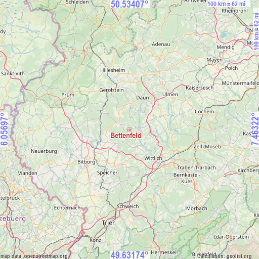
Bettenfeld GPS coordinates[2]
50° 5' 6.108" North, 6° 45' 36.36" East
| Map corner | latitude | longitude |
|---|---|---|
| Upper-left | 50.53407°, | 6.05697° |
| Center: | 50.08503°, | 6.7601° |
| Lower-right: | 49.63174°, | 7.46322° |
| Map W x H: | 100.3×100.3 km | = 62.3×62.3mi |
| max Lat: | 55.01917° ⇑61.6% North |
| Bettenfeld: | 50.08503° |
| min Lat: | ⇓38.4% South 47.40724° |
| min Long | Bettenfeld | max Long |
| 5.92978° | 6.7601° | 14.98853° |
| W 4.1%⇐ | ⇒95.9% E |
Elevation
Elevation of Bettenfeld is 463 m = 1519 ft, and this is 213.9 m = 702 ft above average elevation for this country.
| Max E: |
1256 m = 4121 ft | 15.7% |
| Bettenfeld | 463 m 1519 ft | |
| Avg. | 249.1 m = 817 ft | |
Min E: |
-5 m = -16 ft | 84.3% |
See also: Germany elevation on elevation.city.
Geographical zone
Bettenfeld is located in North temperate zone (between Tropic of Cancer and the Arctic Circle). Distance of this North polar circle is 1832.2 km =1138.5 mi to North.| Distance of | km | miles | from Bettenfeld |
|---|---|---|---|
| North Pole | 4438.1 | 2757.7 | to North |
| Arctic Circle | 1832.2 | 1138.5 | to North |
| Tropic Cancer | 2963 | 1841.1 | to South |
| Equator | 5568.9 | 3460.4 | to South |


Nearby cities:
15 places around Bettenfeld: (largest is in red/bold)
• Bleckhausen
5.6 km =3.5 mi,  17°
17°
• Deudesfeld
2.9 km =1.8 mi,  312°
312°
• Eckfeld
7.3 km =4.5 mi,  61°
61°
• Eisenschmitt
5.3 km =3.3 mi,  210°
210°
• Großlittgen
6.9 km =4.3 mi,  156°
156°
• Karl
4.8 km =3 mi,  143°
143°
• Laufeld
7.6 km =4.7 mi,  91°
91°
• Manderscheid
3.8 km =2.4 mi,  69°
69°
• Meerfeld
1.1 km =0.7 mi,  345°
345°
• Meisburg
6.5 km =4 mi,  302°
302°
• Pantenburg
5.2 km =3.2 mi, 92°
• Schutz
5.4 km =3.4 mi, 352°
• Schwarzenborn
6.5 km =4 mi, 208°
• Weidenbach
6.2 km =3.9 mi,  330°
330°
• Üdersdorf
7.8 km =4.8 mi, 21°
Sources, notices
• [Note1] Compared only with cities in Germany existing in our database
• [Src1] Map data: © OpenStreetMap contributors (CC-BY-SA)
• [Src2] Other city data from geonames.org with taken over terms of usage.
• [Src3] Geographical zone / Annual Mean Temperature by Robert A. Rohde @ Wikipedia
