Schutz geodata
Schutz (Rheinland-Pfalz) is a seat of a fourth-order administrative division; located in Germany in Europe/Berlin (GMT+2) time zone. With population of 161 people, there are 10640 cities with bigger population in this country. Compared to other cities in Germany, 60.7% of cities are located further ↑North; 96.1% of cities are located further →East and 87.7% of cities have lower elevation than Schutz. Note1


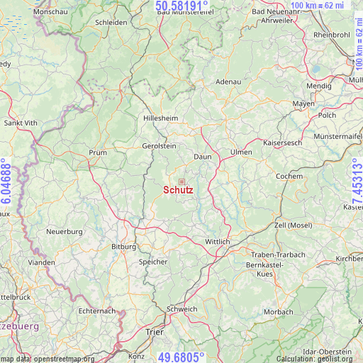
Schutz GPS coordinates[2]
50° 7' 59.988" North, 6° 45' 0" East
| Map corner | latitude | longitude |
|---|---|---|
| Upper-left | 50.58191°, | 6.04688° |
| Center: | 50.13333°, | 6.75° |
| Lower-right: | 49.6805°, | 7.45313° |
| Map W x H: | 100.2×100.2 km | = 62.3×62.3mi |
| max Lat: | 55.01917° ⇑60.7% North |
| Schutz: | 50.13333° |
| min Lat: | ⇓39.3% South 47.40724° |
| min Long | Schutz | max Long |
| 5.92978° | 6.75° | 14.98853° |
| W 3.9%⇐ | ⇒96.1% E |
Elevation
Elevation of Schutz is 491 m = 1611 ft, and this is 241.9 m = 794 ft above average elevation for this country.
| Max E: |
1256 m = 4121 ft | 12.3% |
| Schutz | 491 m 1611 ft | |
| Avg. | 249.1 m = 817 ft | |
Min E: |
-5 m = -16 ft | 87.7% |
See also: Germany elevation on elevation.city.
Geographical zone
Schutz is located in North temperate zone (between Tropic of Cancer and the Arctic Circle). Distance of this North polar circle is 1826.9 km =1135.2 mi to North.| Distance of | km | miles | from Schutz |
|---|---|---|---|
| North Pole | 4432.8 | 2754.4 | to North |
| Arctic Circle | 1826.9 | 1135.2 | to North |
| Tropic Cancer | 2968.4 | 1844.5 | to South |
| Equator | 5574.3 | 3463.7 | to South |


Nearby cities:
15 places around Schutz: (largest is in red/bold)
• Bettenfeld
5.4 km =3.4 mi,  172°
172°
• Bleckhausen
2.4 km =1.5 mi,  90°
90°
• Brockscheid
7.1 km =4.4 mi, 90°
• Deudesfeld
3.7 km =2.3 mi,  201°
201°
• Eckfeld
7.4 km =4.6 mi,  104°
104°
• Manderscheid
5.9 km =3.7 mi,  133°
133°
• Meerfeld
4.4 km =2.7 mi, 173°
• Meisburg
5.1 km =3.2 mi,  248°
248°
• Neroth
7 km =4.3 mi,  358°
358°
• Niederstadtfeld
3.1 km =1.9 mi,  12°
12°
• Oberstadtfeld
5 km =3.1 mi,  16°
16°
• Salm
4.8 km =3 mi,  297°
297°
• Wallenborn
3 km =1.9 mi,  307°
307°
• Weidenbach
2.4 km =1.5 mi,  270°
270°
• Üdersdorf
4 km =2.5 mi,  62°
62°
Sources, notices
• [Note1] Compared only with cities in Germany existing in our database
• [Src1] Map data: © OpenStreetMap contributors (CC-BY-SA)
• [Src2] Other city data from geonames.org with taken over terms of usage.
• [Src3] Geographical zone / Annual Mean Temperature by Robert A. Rohde @ Wikipedia
