Bermersheim geodata
Bermersheim (Rheinland-Pfalz) is a seat of a fourth-order administrative division; located in Germany in Europe/Berlin (GMT+2) time zone. In our database, there are 11009 cities with bigger population. Compared to other cities in Germany, 71.9% of cities are located further ↑North; 73.8% of cities are located further →East and 56.5% of cities have higher elevation than Bermersheim. Note1
Administrative division(s):
- Level 1: Rheinland-Pfalz
- Level 3: Landkreis Alzey-Worms
- Level 4: Bermersheim


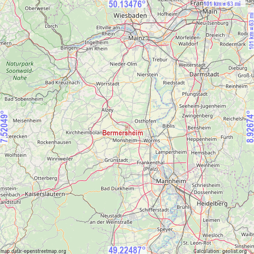
Bermersheim GPS coordinates[2]
49° 40' 54.984" North, 8° 13' 24.996" East
| Map corner | latitude | longitude |
|---|---|---|
| Upper-left | 50.13476°, | 7.52049° |
| Center: | 49.68194°, | 8.22361° |
| Lower-right: | 49.22487°, | 8.92674° |
| Map W x H: | 101.2×101.2 km | = 62.9×62.9mi |
| max Lat: | 55.01917° ⇑71.9% North |
| Bermersheim: | 49.68194° |
| min Lat: | ⇓28.1% South 47.40724° |
| min Long | Bermersheim | max Long |
| 5.92978° | 8.22361° | 14.98853° |
| W 26.2%⇐ | ⇒73.8% E |
Elevation
Elevation of Bermersheim is 178 m = 584 ft, and this is 71.1 m = 233 ft below average elevation for this country.
| Max E: |
1256 m = 4121 ft | 56.5% |
| Avg. | 249.1 m = 817 ft | |
| Bermersheim | 178 m = 584 ft | |
Min E: |
-5 m = -16 ft | 43.5% |
See also: Germany elevation on elevation.city.
Geographical zone
Bermersheim is located in North temperate zone (between Tropic of Cancer and the Arctic Circle). Distance of this North polar circle is 1877.1 km =1166.4 mi to North.| Distance of | km | miles | from Bermersheim |
|---|---|---|---|
| North Pole | 4482.9 | 2785.5 | to North |
| Arctic Circle | 1877.1 | 1166.4 | to North |
| Tropic Cancer | 2918.2 | 1813.3 | to South |
| Equator | 5524.1 | 3432.5 | to South |


Nearby cities:
15 places around Bermersheim: (largest is in red/bold)
• Dintesheim
6.4 km =4 mi,  296°
296°
• Dittelsheim-Heßloch
7 km =4.3 mi,  7°
7°
• Eppelsheim
4.9 km =3 mi, 302°
• Flomborn
5.4 km =3.4 mi,  280°
280°
• Gundersheim
2.2 km =1.4 mi,  316°
316°
• Gundheim
1.2 km =0.7 mi,  123°
123°
• Hangen-Weisheim
4.3 km =2.7 mi, 317°
• Hochborn
4.9 km =3 mi,  340°
340°
• Monsheim
5 km =3.1 mi,  189°
189°
• Monzernheim
4.4 km =2.7 mi,  4°
4°
• Mölsheim
5.5 km =3.4 mi,  224°
224°
• Mörstadt
3.2 km =2 mi,  134°
134°
• Ober-Flörsheim
4.9 km =3 mi,  271°
271°
• Wachenheim
6.5 km =4 mi, 220°
• Westhofen
3.1 km =1.9 mi,  35°
35°
Sources, notices
• [Note1] Compared only with cities in Germany existing in our database
• [Src1] Map data: © OpenStreetMap contributors (CC-BY-SA)
• [Src2] Other city data from geonames.org with taken over terms of usage.
• [Src3] Geographical zone / Annual Mean Temperature by Robert A. Rohde @ Wikipedia
