Monsheim geodata
Monsheim (Rheinland-Pfalz) is a seat of a fourth-order administrative division; located in Germany in Europe/Berlin (GMT+2) time zone. With population of 2,624 people, there are 4308 cities with bigger population in this country. Compared to other cities in Germany, 72.8% of cities are located further ↑North; 73.9% of cities are located further →East and 62.9% of cities have higher elevation than Monsheim. Note1
Administrative division(s):
- Level 1: Rheinland-Pfalz
- Level 3: Landkreis Alzey-Worms
- Level 4: Monsheim


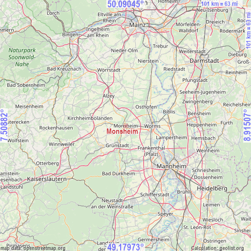
Monsheim GPS coordinates[2]
49° 38' 13.992" North, 8° 12' 42.984" East
| Map corner | latitude | longitude |
|---|---|---|
| Upper-left | 50.09045°, | 7.50882° |
| Center: | 49.63722°, | 8.21194° |
| Lower-right: | 49.17973°, | 8.91507° |
| Map W x H: | 101.3×101.3 km | = 62.9×62.9mi |
| max Lat: | 55.01917° ⇑72.8% North |
| Monsheim: | 49.63722° |
| min Lat: | ⇓27.2% South 47.40724° |
| min Long | Monsheim | max Long |
| 5.92978° | 8.21194° | 14.98853° |
| W 26.1%⇐ | ⇒73.9% E |
Elevation
Elevation of Monsheim is 133 m = 436 ft, and this is 116.1 m = 381 ft below average elevation for this country.
| Max E: |
1256 m = 4121 ft | 62.9% |
| Avg. | 249.1 m = 817 ft | |
| Monsheim | 133 m = 436 ft | |
Min E: |
-5 m = -16 ft | 37.1% |
See also: Germany elevation on elevation.city.
Geographical zone
Monsheim is located in North temperate zone (between Tropic of Cancer and the Arctic Circle). Distance of this North polar circle is 1882 km =1169.4 mi to North.| Distance of | km | miles | from Monsheim |
|---|---|---|---|
| North Pole | 4487.9 | 2788.7 | to North |
| Arctic Circle | 1882 | 1169.4 | to North |
| Tropic Cancer | 2913.2 | 1810.2 | to South |
| Equator | 5519.1 | 3429.4 | to South |


Nearby cities:
15 places around Monsheim: (largest is in red/bold)
• Bermersheim
5 km =3.1 mi,  9°
9°
• Bockenheim
3.9 km =2.4 mi,  209°
209°
• Bubenheim
6.9 km =4.3 mi,  261°
261°
• Einselthum
6.5 km =4 mi,  284°
284°
• Gundersheim
6.6 km =4.1 mi,  354°
354°
• Gundheim
4.7 km =2.9 mi,  23°
23°
• Heidesheim
6.2 km =3.9 mi,  191°
191°
• Hohen-Sülzen
2.2 km =1.4 mi,  153°
153°
• Kindenheim
4.5 km =2.8 mi,  229°
229°
• Mölsheim
3.2 km =2 mi,  288°
288°
• Mörstadt
4.1 km =2.5 mi,  48°
48°
• Ober-Flörsheim
6.5 km =4 mi,  321°
321°
• Obrigheim
5.1 km =3.2 mi, 185°
• Offstein
3.9 km =2.4 mi, 151°
• Wachenheim
3.4 km =2.1 mi,  270°
270°
Sources, notices
• [Note1] Compared only with cities in Germany existing in our database
• [Src1] Map data: © OpenStreetMap contributors (CC-BY-SA)
• [Src2] Other city data from geonames.org with taken over terms of usage.
• [Src3] Geographical zone / Annual Mean Temperature by Robert A. Rohde @ Wikipedia
