Balgheim geodata
Balgheim (Baden-Württemberg) is a seat of a fourth-order administrative division; located in Germany in Europe/Berlin (GMT+2) time zone. With population of 981 people, there are 7247 cities with bigger population in this country. Compared to other cities in Germany, 94.6% of cities are located further ↑North; 68.3% of cities are located further →East and 97.8% of cities have lower elevation than Balgheim. Note1
Administrative division(s):
- Level 1: Baden-Württemberg
- Level 2: Freiburg Region
- Level 3: Landkreis Tuttlingen
- Level 4: Balgheim


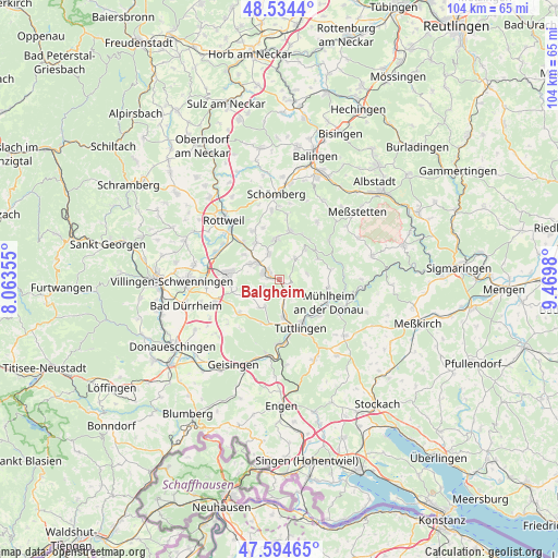
Balgheim GPS coordinates[2]
48° 4' 0.012" North, 8° 46' 0.012" East
| Map corner | latitude | longitude |
|---|---|---|
| Upper-left | 48.5344°, | 8.06355° |
| Center: | 48.06667°, | 8.76667° |
| Lower-right: | 47.59465°, | 9.4698° |
| Map W x H: | 104.5×104.5 km | = 64.9×64.9mi |
| max Lat: | 55.01917° ⇑94.6% North |
| Balgheim: | 48.06667° |
| min Lat: | ⇓5.4% South 47.40724° |
| min Long | Balgheim | max Long |
| 5.92978° | 8.76667° | 14.98853° |
| W 31.7%⇐ | ⇒68.3% E |
Elevation
Elevation of Balgheim is 697 m = 2287 ft, and this is 447.9 m = 1469 ft above average elevation for this country.
| Max E: |
1256 m = 4121 ft | 2.2% |
| Balgheim | 697 m 2287 ft | |
| Avg. | 249.1 m = 817 ft | |
Min E: |
-5 m = -16 ft | 97.8% |
See also: Germany elevation on elevation.city.
Geographical zone
Balgheim is located in North temperate zone (between Tropic of Cancer and the Arctic Circle). Distance of this North polar circle is 2056.7 km =1278 mi to North.| Distance of | km | miles | from Balgheim |
|---|---|---|---|
| North Pole | 4662.5 | 2897.1 | to North |
| Arctic Circle | 2056.7 | 1278 | to North |
| Tropic Cancer | 2738.6 | 1701.7 | to South |
| Equator | 5344.5 | 3320.9 | to South |


Nearby cities:
15 places around Balgheim: (largest is in red/bold)
• Aldingen
6.2 km =3.9 mi,  306°
306°
• Bubsheim
7.4 km =4.6 mi,  41°
41°
• Böttingen
4.5 km =2.8 mi,  33°
33°
• Denkingen
5.4 km =3.4 mi,  336°
336°
• Durchhausen
7.4 km =4.6 mi,  246°
246°
• Dürbheim
2.3 km =1.4 mi,  120°
120°
• Frittlingen
8 km =5 mi,  326°
326°
• Gosheim
7.6 km =4.7 mi,  353°
353°
• Gunningen
5.3 km =3.3 mi, 249°
• Hausen ob Verena
3.4 km =2.1 mi, 245°
• Königsheim
8.3 km =5.2 mi,  63°
63°
• Rietheim-Weilheim
5.6 km =3.5 mi,  180°
180°
• Seitingen-Oberflacht
6.7 km =4.2 mi,  213°
213°
• Spaichingen
2.5 km =1.6 mi,  290°
290°
• Wurmlingen
7.5 km =4.7 mi,  170°
170°
Sources, notices
• [Note1] Compared only with cities in Germany existing in our database
• [Src1] Map data: © OpenStreetMap contributors (CC-BY-SA)
• [Src2] Other city data from geonames.org with taken over terms of usage.
• [Src3] Geographical zone / Annual Mean Temperature by Robert A. Rohde @ Wikipedia
