Wurmlingen geodata
Wurmlingen (Baden-Württemberg) is a seat of a fourth-order administrative division; located in Germany in Europe/Berlin (GMT+2) time zone. With population of 3,812 people, there are 3397 cities with bigger population in this country. Compared to other cities in Germany, 95.6% of cities are located further ↑North; 68.2% of cities are located further →East and 97.3% of cities have lower elevation than Wurmlingen. Note1
Administrative division(s):
- Level 1: Baden-Württemberg
- Level 2: Freiburg Region
- Level 3: Landkreis Tuttlingen
- Level 4: Wurmlingen


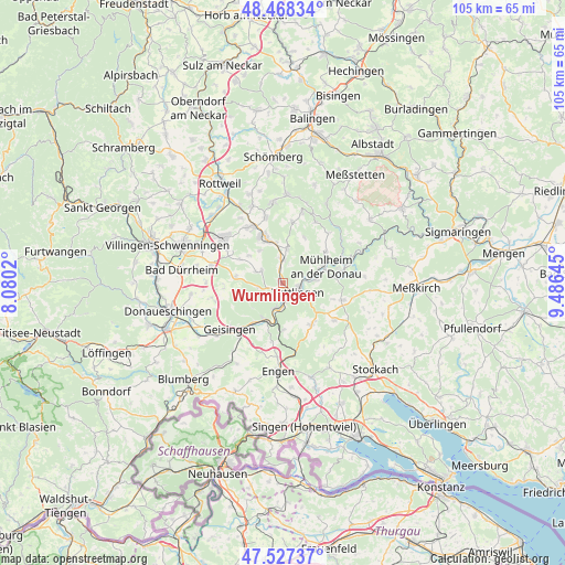
Wurmlingen GPS coordinates[2]
48° 0' 0" North, 8° 46' 59.988" East
| Map corner | latitude | longitude |
|---|---|---|
| Upper-left | 48.46834°, | 8.0802° |
| Center: | 48°, | 8.78333° |
| Lower-right: | 47.52737°, | 9.48645° |
| Map W x H: | 104.6×104.6 km | = 65×65mi |
| max Lat: | 55.01917° ⇑95.6% North |
| Wurmlingen: | 48° |
| min Lat: | ⇓4.4% South 47.40724° |
| min Long | Wurmlingen | max Long |
| 5.92978° | 8.78333° | 14.98853° |
| W 31.8%⇐ | ⇒68.2% E |
Elevation
Elevation of Wurmlingen is 677 m = 2221 ft, and this is 427.9 m = 1404 ft above average elevation for this country.
| Max E: |
1256 m = 4121 ft | 2.7% |
| Wurmlingen | 677 m 2221 ft | |
| Avg. | 249.1 m = 817 ft | |
Min E: |
-5 m = -16 ft | 97.3% |
See also: Germany elevation on elevation.city.
Geographical zone
Wurmlingen is located in North temperate zone (between Tropic of Cancer and the Arctic Circle). Distance of this North polar circle is 2064.1 km =1282.6 mi to North.| Distance of | km | miles | from Wurmlingen |
|---|---|---|---|
| North Pole | 4670 | 2901.8 | to North |
| Arctic Circle | 2064.1 | 1282.6 | to North |
| Tropic Cancer | 2731.2 | 1697.1 | to South |
| Equator | 5337.1 | 3316.3 | to South |


Nearby cities:
15 places around Wurmlingen: (largest is in red/bold)
• Balgheim
7.5 km =4.7 mi,  350°
350°
• Böttingen
11.2 km =7 mi,  6°
6°
• Durchhausen
9.2 km =5.7 mi,  298°
298°
• Dürbheim
6.3 km =3.9 mi, 6°
• Emmingen-Liptingen
10.5 km =6.5 mi,  134°
134°
• Fridingen an der Donau
10.6 km =6.6 mi,  78°
78°
• Gunningen
8.3 km =5.2 mi,  311°
311°
• Hausen ob Verena
7.4 km =4.6 mi,  323°
323°
• Immendingen
8.3 km =5.2 mi,  206°
206°
• Kolbingen
9.8 km =6.1 mi,  53°
53°
• Rietheim-Weilheim
2.2 km =1.4 mi,  326°
326°
• Seitingen-Oberflacht
5.3 km =3.3 mi,  290°
290°
• Spaichingen
9.1 km =5.7 mi,  336°
336°
• Talheim
8.9 km =5.5 mi,  282°
282°
• Tuttlingen
3.1 km =1.9 mi,  123°
123°
Sources, notices
• [Note1] Compared only with cities in Germany existing in our database
• [Src1] Map data: © OpenStreetMap contributors (CC-BY-SA)
• [Src2] Other city data from geonames.org with taken over terms of usage.
• [Src3] Geographical zone / Annual Mean Temperature by Robert A. Rohde @ Wikipedia
