Rietheim-Weilheim geodata
Rietheim-Weilheim (Baden-Württemberg) is a seat of a fourth-order administrative division; located in Germany in Europe/Berlin (GMT+2) time zone. With population of 2,649 people, there are 4284 cities with bigger population in this country. Compared to other cities in Germany, 95.3% of cities are located further ↑North; 68.3% of cities are located further →East and 98.8% of cities have lower elevation than Rietheim-Weilheim. Note1
Administrative division(s):
- Level 1: Baden-Württemberg
- Level 2: Freiburg Region
- Level 3: Landkreis Tuttlingen
- Level 4: Rietheim-Weilheim


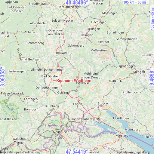
Rietheim-Weilheim GPS coordinates[2]
48° 1' 0.012" North, 8° 46' 0.012" East
| Map corner | latitude | longitude |
|---|---|---|
| Upper-left | 48.48486°, | 8.06355° |
| Center: | 48.01667°, | 8.76667° |
| Lower-right: | 47.54419°, | 9.4698° |
| Map W x H: | 104.6×104.6 km | = 65×65mi |
| max Lat: | 55.01917° ⇑95.3% North |
| Rietheim-Weilheim: | 48.01667° |
| min Lat: | ⇓4.7% South 47.40724° |
| min Long | Rietheim-Weilhe | max Long |
| 5.92978° | 8.76667° | 14.98853° |
| W 31.7%⇐ | ⇒68.3% E |
Elevation
Elevation of Rietheim-Weilheim is 760 m = 2493 ft, and this is 510.9 m = 1676 ft above average elevation for this country.
| Max E: |
1256 m = 4121 ft | 1.2% |
| Rietheim-Weilheim | 760 m 2493 ft | |
| Avg. | 249.1 m = 817 ft | |
Min E: |
-5 m = -16 ft | 98.8% |
See also: Germany elevation on elevation.city.
Geographical zone
Rietheim-Weilheim is located in North temperate zone (between Tropic of Cancer and the Arctic Circle). Distance of this North polar circle is 2062.2 km =1281.4 mi to North.| Distance of | km | miles | from Rietheim-Weilheim |
|---|---|---|---|
| North Pole | 4668.1 | 2900.6 | to North |
| Arctic Circle | 2062.2 | 1281.4 | to North |
| Tropic Cancer | 2733 | 1698.2 | to South |
| Equator | 5339 | 3317.5 | to South |


Nearby cities:
15 places around Rietheim-Weilheim: (largest is in red/bold)
• Aldingen
10.5 km =6.5 mi,  331°
331°
• Balgheim
5.6 km =3.5 mi,  0°
0°
• Böttingen
9.6 km =6 mi,  14°
14°
• Denkingen
10.7 km =6.6 mi,  348°
348°
• Durchhausen
7.3 km =4.5 mi,  290°
290°
• Dürbheim
4.8 km =3 mi,  24°
24°
• Gunningen
6.2 km =3.9 mi,  306°
306°
• Hausen ob Verena
5.2 km =3.2 mi,  322°
322°
• Immendingen
9.6 km =6 mi,  194°
194°
• Kolbingen
10 km =6.2 mi,  66°
66°
• Seitingen-Oberflacht
3.7 km =2.3 mi,  270°
270°
• Spaichingen
6.9 km =4.3 mi,  340°
340°
• Talheim
7.4 km =4.6 mi, 270°
• Tuttlingen
5.2 km =3.2 mi,  133°
133°
• Wurmlingen
2.2 km =1.4 mi,  146°
146°
Sources, notices
• [Note1] Compared only with cities in Germany existing in our database
• [Src1] Map data: © OpenStreetMap contributors (CC-BY-SA)
• [Src2] Other city data from geonames.org with taken over terms of usage.
• [Src3] Geographical zone / Annual Mean Temperature by Robert A. Rohde @ Wikipedia
