Ayl geodata
Ayl (Rheinland-Pfalz) is a seat of a fourth-order administrative division; located in Germany in Europe/Berlin (GMT+2) time zone. With population of 1,479 people, there are 5922 cities with bigger population in this country. Compared to other cities in Germany, 73% of cities are located further ↑North; 97.5% of cities are located further →East and 57.2% of cities have higher elevation than Ayl. Note1


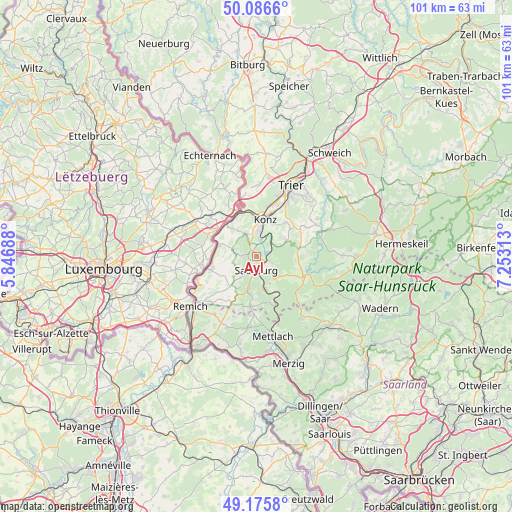
Ayl GPS coordinates[2]
49° 37' 59.988" North, 6° 33' 0" East
| Map corner | latitude | longitude |
|---|---|---|
| Upper-left | 50.0866°, | 5.84688° |
| Center: | 49.63333°, | 6.55° |
| Lower-right: | 49.1758°, | 7.25313° |
| Map W x H: | 101.3×101.3 km | = 62.9×62.9mi |
| max Lat: | 55.01917° ⇑73% North |
| Ayl: | 49.63333° |
| min Lat: | ⇓27% South 47.40724° |
| min Long | Ayl | max Long |
| 5.92978° | 6.55° | 14.98853° |
| W 2.5%⇐ | ⇒97.5% E |
Elevation
Elevation of Ayl is 173 m = 568 ft, and this is 76.1 m = 250 ft below average elevation for this country.
| Max E: |
1256 m = 4121 ft | 57.2% |
| Avg. | 249.1 m = 817 ft | |
| Ayl | 173 m = 568 ft | |
Min E: |
-5 m = -16 ft | 42.8% |
See also: Germany elevation on elevation.city.
Geographical zone
Ayl is located in North temperate zone (between Tropic of Cancer and the Arctic Circle). Distance of this North polar circle is 1882.5 km =1169.7 mi to North.| Distance of | km | miles | from Ayl |
|---|---|---|---|
| North Pole | 4488.4 | 2789 | to North |
| Arctic Circle | 1882.5 | 1169.7 | to North |
| Tropic Cancer | 2912.8 | 1809.9 | to South |
| Equator | 5518.7 | 3429.2 | to South |


Nearby cities:
15 places around Ayl: (largest is in red/bold)
• Fisch
5.1 km =3.2 mi,  248°
248°
• Irsch
4.6 km =2.9 mi,  134°
134°
• Kanzem
4.2 km =2.6 mi,  28°
28°
• Mannebach
2.4 km =1.5 mi,  270°
270°
• Merzkirchen
7.3 km =4.5 mi,  220°
220°
• Nittel
7.4 km =4.6 mi,  284°
284°
• Ockfen
3 km =1.9 mi, 127°
• Onsdorf
5.1 km =3.2 mi,  291°
291°
• Saarburg
3 km =1.9 mi,  188°
188°
• Schoden
2.4 km =1.5 mi,  90°
90°
• Serrig
6.7 km =4.2 mi,  164°
164°
• Tawern
4.4 km =2.7 mi,  327°
327°
• Trassem
6.4 km =4 mi,  196°
196°
• Wawern
1.9 km =1.2 mi,  0°
0°
• Wiltingen
4.2 km =2.6 mi,  46°
46°
Sources, notices
• [Note1] Compared only with cities in Germany existing in our database
• [Src1] Map data: © OpenStreetMap contributors (CC-BY-SA)
• [Src2] Other city data from geonames.org with taken over terms of usage.
• [Src3] Geographical zone / Annual Mean Temperature by Robert A. Rohde @ Wikipedia
