Saarburg geodata
Saarburg (Rheinland-Pfalz) is a populated place; located in Germany in Europe/Berlin (GMT+2) time zone. With population of 6,222 people, there are 2392 cities with bigger population in this country. Compared to other cities in Germany, 73.6% of cities are located further ↑North; 97.5% of cities are located further →East and 56.7% of cities have higher elevation than Saarburg. Note1
Administrative division(s):
- Level 1: Rheinland-Pfalz
- Level 3: Landkreis Trier-Saarburg
- Level 4: Saarburg


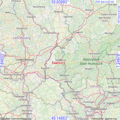
Saarburg GPS coordinates[2]
49° 36' 23.076" North, 6° 32' 37.14" East
| Map corner | latitude | longitude |
|---|---|---|
| Upper-left | 50.05993°, | 5.84053° |
| Center: | 49.60641°, | 6.54365° |
| Lower-right: | 49.14863°, | 7.24678° |
| Map W x H: | 101.3×101.3 km | = 62.9×62.9mi |
| max Lat: | 55.01917° ⇑73.6% North |
| Saarburg: | 49.60641° |
| min Lat: | ⇓26.4% South 47.40724° |
| min Long | Saarburg | max Long |
| 5.92978° | 6.54365° | 14.98853° |
| W 2.5%⇐ | ⇒97.5% E |
Elevation
Elevation of Saarburg is 177 m = 581 ft, and this is 72.1 m = 237 ft below average elevation for this country.
| Max E: |
1256 m = 4121 ft | 56.7% |
| Avg. | 249.1 m = 817 ft | |
| Saarburg | 177 m = 581 ft | |
Min E: |
-5 m = -16 ft | 43.3% |
See also: Germany elevation on elevation.city.
Geographical zone
Saarburg is located in North temperate zone (between Tropic of Cancer and the Arctic Circle). Distance of this North polar circle is 1885.5 km =1171.6 mi to North.| Distance of | km | miles | from Saarburg |
|---|---|---|---|
| North Pole | 4491.3 | 2790.8 | to North |
| Arctic Circle | 1885.5 | 1171.6 | to North |
| Tropic Cancer | 2909.8 | 1808.1 | to South |
| Equator | 5515.7 | 3427.3 | to South |


Nearby cities:
15 places around Saarburg: (largest is in red/bold)
• Ayl
3 km =1.9 mi,  8°
8°
• Fisch
4.5 km =2.8 mi,  284°
284°
• Freudenburg
7 km =4.3 mi,  186°
186°
• Irsch
3.7 km =2.3 mi,  92°
92°
• Kastel-Staadt
4.7 km =2.9 mi,  166°
166°
• Mannebach
3.6 km =2.2 mi,  327°
327°
• Merzkirchen
5 km =3.1 mi,  239°
239°
• Ockfen
3.1 km =1.9 mi,  68°
68°
• Onsdorf
6.5 km =4 mi,  318°
318°
• Schoden
4.1 km =2.5 mi,  43°
43°
• Serrig
4.1 km =2.5 mi,  147°
147°
• Taben-Rodt
6.9 km =4.3 mi,  155°
155°
• Trassem
3.4 km =2.1 mi,  202°
202°
• Wawern
4.9 km =3 mi, 5°
• Wiltingen
6.8 km =4.2 mi,  30°
30°
Sources, notices
• [Note1] Compared only with cities in Germany existing in our database
• [Src1] Map data: © OpenStreetMap contributors (CC-BY-SA)
• [Src2] Other city data from geonames.org with taken over terms of usage.
• [Src3] Geographical zone / Annual Mean Temperature by Robert A. Rohde @ Wikipedia
