Onsdorf geodata
Onsdorf (Rheinland-Pfalz) is a seat of a fourth-order administrative division; located in Germany in Europe/Berlin (GMT+2) time zone. With population of 151 people, there are 10683 cities with bigger population in this country. Compared to other cities in Germany, 72.6% of cities are located further ↑North; 97.9% of cities are located further →East and 63.6% of cities have lower elevation than Onsdorf. Note1
Administrative division(s):
- Level 1: Rheinland-Pfalz
- Level 3: Landkreis Trier-Saarburg
- Level 4: Onsdorf


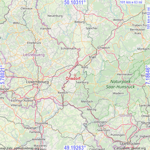
Onsdorf GPS coordinates[2]
49° 39' 0" North, 6° 28' 59.988" East
| Map corner | latitude | longitude |
|---|---|---|
| Upper-left | 50.10311°, | 5.78021° |
| Center: | 49.65°, | 6.48333° |
| Lower-right: | 49.19263°, | 7.18646° |
| Map W x H: | 101.2×101.2 km | = 62.9×62.9mi |
| max Lat: | 55.01917° ⇑72.6% North |
| Onsdorf: | 49.65° |
| min Lat: | ⇓27.4% South 47.40724° |
| min Long | Onsdorf | max Long |
| 5.92978° | 6.48333° | 14.98853° |
| W 2.1%⇐ | ⇒97.9% E |
Elevation
Elevation of Onsdorf is 312 m = 1024 ft, and this is 62.9 m = 206 ft above average elevation for this country.
| Max E: |
1256 m = 4121 ft | 36.4% |
| Onsdorf | 312 m 1024 ft | |
| Avg. | 249.1 m = 817 ft | |
Min E: |
-5 m = -16 ft | 63.6% |
See also: Germany elevation on elevation.city.
Geographical zone
Onsdorf is located in North temperate zone (between Tropic of Cancer and the Arctic Circle). Distance of this North polar circle is 1880.6 km =1168.6 mi to North.| Distance of | km | miles | from Onsdorf |
|---|---|---|---|
| North Pole | 4486.5 | 2787.8 | to North |
| Arctic Circle | 1880.6 | 1168.6 | to North |
| Tropic Cancer | 2914.6 | 1811 | to South |
| Equator | 5520.6 | 3430.3 | to South |


Nearby cities:
15 places around Onsdorf: (largest is in red/bold)
• Ayl
5.1 km =3.2 mi,  111°
111°
• Fisch
3.7 km =2.3 mi,  180°
180°
• Kanzem
7.1 km =4.4 mi,  74°
74°
• Mannebach
3 km =1.9 mi,  127°
127°
• Merzkirchen
7.4 km =4.6 mi, 180°
• Nittel
2.4 km =1.5 mi,  270°
270°
• Oberbillig
6.8 km =4.2 mi,  14°
14°
• Saarburg
6.5 km =4 mi,  138°
138°
• Schoden
7.4 km =4.6 mi,  104°
104°
• Tawern
3 km =1.9 mi,  52°
52°
• Temmels
4.5 km =2.8 mi,  343°
343°
• Wasserliesch
7.6 km =4.7 mi,  32°
32°
• Wawern
4.8 km =3 mi,  90°
90°
• Wellen
4 km =2.5 mi,  297°
297°
• Wincheringen
6.1 km =3.8 mi,  222°
222°
Sources, notices
• [Note1] Compared only with cities in Germany existing in our database
• [Src1] Map data: © OpenStreetMap contributors (CC-BY-SA)
• [Src2] Other city data from geonames.org with taken over terms of usage.
• [Src3] Geographical zone / Annual Mean Temperature by Robert A. Rohde @ Wikipedia
