Augsdorf geodata
Augsdorf (Saxony-Anhalt) is a populated place; located in Germany in Europe/Berlin (GMT+2) time zone. With population of 623 people, there are 8698 cities with bigger population in this country. Compared to other cities in Germany, 67.7% of cities are located further ↓South; 75.4% of cities are located further ←West and 55.5% of cities have higher elevation than Augsdorf. Note1


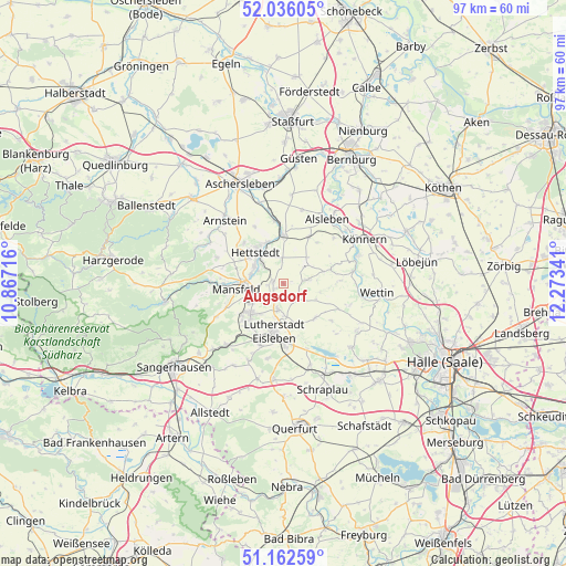
Augsdorf GPS coordinates[2]
51° 36' 5.112" North, 11° 34' 13.008" East
| Map corner | latitude | longitude |
|---|---|---|
| Upper-left | 52.03605°, | 10.86716° |
| Center: | 51.60142°, | 11.57028° |
| Lower-right: | 51.16259°, | 12.27341° |
| Map W x H: | 97.1×97.1 km | = 60.3×60.3mi |
| max Lat: | 55.01917° ⇑32.3% North |
| Augsdorf: | 51.60142° |
| min Lat: | ⇓67.7% South 47.40724° |
| min Long | Augsdorf | max Long |
| 5.92978° | 11.57028° | 14.98853° |
| W 75.4%⇐ | ⇒24.6% E |
Elevation
Elevation of Augsdorf is 185 m = 607 ft, and this is 64.1 m = 210 ft below average elevation for this country.
| Max E: |
1256 m = 4121 ft | 55.5% |
| Avg. | 249.1 m = 817 ft | |
| Augsdorf | 185 m = 607 ft | |
Min E: |
-5 m = -16 ft | 44.5% |
See also: Germany elevation on elevation.city.
Geographical zone
Augsdorf is located in North temperate zone (between Tropic of Cancer and the Arctic Circle). Distance of this North polar circle is 1663.6 km =1033.7 mi to North.| Distance of | km | miles | from Augsdorf |
|---|---|---|---|
| North Pole | 4269.5 | 2652.9 | to North |
| Arctic Circle | 1663.6 | 1033.7 | to North |
| Tropic Cancer | 3131.6 | 1945.9 | to South |
| Equator | 5737.5 | 3565.1 | to South |


Nearby cities:
15 places around Augsdorf: (largest is in red/bold)
• Benndorf
6.4 km =4 mi,  237°
237°
• Eisleben Lutherstadt
8.4 km =5.2 mi,  190°
190°
• Gerbstedt
5.2 km =3.2 mi,  48°
48°
• Großörner
5.8 km =3.6 mi,  285°
285°
• Hedersleben
8 km =5 mi,  136°
136°
• Heiligenthal
4.4 km =2.7 mi,  79°
79°
• Helbra
7.5 km =4.7 mi,  220°
220°
• Hettstedt
6.8 km =4.2 mi,  323°
323°
• Klostermansfeld
5.3 km =3.3 mi,  247°
247°
• Mansfeld
8.2 km =5.1 mi,  262°
262°
• Polleben
3.1 km =1.9 mi, 140°
• Sandersleben
8.5 km =5.3 mi,  358°
358°
• Siersleben
1.9 km =1.2 mi,  279°
279°
• Volkstedt
4.4 km =2.7 mi, 192°
• Wiederstedt
7.7 km =4.8 mi,  337°
337°
Sources, notices
• [Note1] Compared only with cities in Germany existing in our database
• [Src1] Map data: © OpenStreetMap contributors (CC-BY-SA)
• [Src2] Other city data from geonames.org with taken over terms of usage.
• [Src3] Geographical zone / Annual Mean Temperature by Robert A. Rohde @ Wikipedia
