Volkstedt geodata
Volkstedt (Saxony-Anhalt) is a populated place; located in Germany in Europe/Berlin (GMT+2) time zone. With population of 1,307 people, there are 6291 cities with bigger population in this country. Compared to other cities in Germany, 67% of cities are located further ↓South; 75.1% of cities are located further ←West and 60% of cities have higher elevation than Volkstedt. Note1
Administrative division(s):
- Level 1: Saxony-Anhalt
- Level 3: Mansfeld-Südharz
- Level 4: Eisleben, Lutherstadt


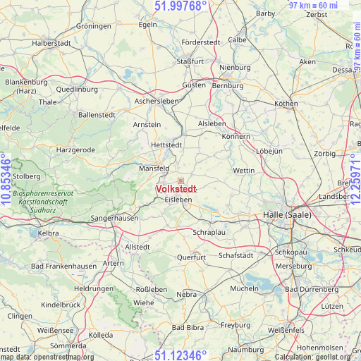
Volkstedt GPS coordinates[2]
51° 33' 45.612" North, 11° 33' 23.688" East
| Map corner | latitude | longitude |
|---|---|---|
| Upper-left | 51.99768°, | 10.85346° |
| Center: | 51.56267°, | 11.55658° |
| Lower-right: | 51.12346°, | 12.25971° |
| Map W x H: | 97.2×97.2 km | = 60.4×60.4mi |
| max Lat: | 55.01917° ⇑33% North |
| Volkstedt: | 51.56267° |
| min Lat: | ⇓67% South 47.40724° |
| min Long | Volkstedt | max Long |
| 5.92978° | 11.55658° | 14.98853° |
| W 75.1%⇐ | ⇒24.9% E |
Elevation
Elevation of Volkstedt is 152 m = 499 ft, and this is 97.1 m = 319 ft below average elevation for this country.
| Max E: |
1256 m = 4121 ft | 60% |
| Avg. | 249.1 m = 817 ft | |
| Volkstedt | 152 m = 499 ft | |
Min E: |
-5 m = -16 ft | 40% |
See also: Germany elevation on elevation.city.
Geographical zone
Volkstedt is located in North temperate zone (between Tropic of Cancer and the Arctic Circle). Distance of this North polar circle is 1667.9 km =1036.4 mi to North.| Distance of | km | miles | from Volkstedt |
|---|---|---|---|
| North Pole | 4273.8 | 2655.6 | to North |
| Arctic Circle | 1667.9 | 1036.4 | to North |
| Tropic Cancer | 3127.3 | 1943.2 | to South |
| Equator | 5733.2 | 3562.4 | to South |


Nearby cities:
15 places around Volkstedt: (largest is in red/bold)
• Ahlsdorf
6.5 km =4 mi,  252°
252°
• Augsdorf
4.4 km =2.7 mi,  12°
12°
• Benndorf
4.5 km =2.8 mi,  280°
280°
• Eisleben Lutherstadt
3.9 km =2.4 mi,  188°
188°
• Großörner
7.4 km =4.6 mi,  321°
321°
• Hedersleben
6.6 km =4.1 mi,  103°
103°
• Heiligenthal
7.4 km =4.6 mi,  46°
46°
• Helbra
4.2 km =2.6 mi, 250°
• Hergisdorf
6 km =3.7 mi,  237°
237°
• Klostermansfeld
4.5 km =2.8 mi,  300°
300°
• Mansfeld
7.9 km =4.9 mi,  294°
294°
• Polleben
3.5 km =2.2 mi,  57°
57°
• Siersleben
4.7 km =2.9 mi,  348°
348°
• Wimmelburg
5.8 km =3.6 mi,  216°
216°
• Wolferode
6.9 km =4.3 mi,  205°
205°
Sources, notices
• [Note1] Compared only with cities in Germany existing in our database
• [Src1] Map data: © OpenStreetMap contributors (CC-BY-SA)
• [Src2] Other city data from geonames.org with taken over terms of usage.
• [Src3] Geographical zone / Annual Mean Temperature by Robert A. Rohde @ Wikipedia
