Helbra geodata
Helbra (Saxony-Anhalt) is a seat of a fourth-order administrative division; located in Germany in Europe/Berlin (GMT+2) time zone. With population of 4,723 people, there are 2935 cities with bigger population in this country. Compared to other cities in Germany, 66.9% of cities are located further ↓South; 74.3% of cities are located further ←West and 53.9% of cities have lower elevation than Helbra. Note1


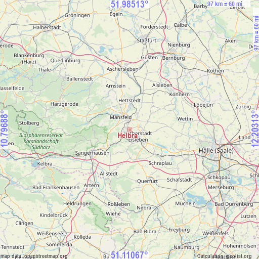
Helbra GPS coordinates[2]
51° 33' 0" North, 11° 30' 0" East
| Map corner | latitude | longitude |
|---|---|---|
| Upper-left | 51.98513°, | 10.79688° |
| Center: | 51.55°, | 11.5° |
| Lower-right: | 51.11067°, | 12.20313° |
| Map W x H: | 97.2×97.2 km | = 60.4×60.4mi |
| max Lat: | 55.01917° ⇑33.1% North |
| Helbra: | 51.55° |
| min Lat: | ⇓66.9% South 47.40724° |
| min Long | Helbra | max Long |
| 5.92978° | 11.5° | 14.98853° |
| W 74.3%⇐ | ⇒25.7% E |
Elevation
Elevation of Helbra is 251 m = 823 ft, and this is 1.9 m = 6 ft above average elevation for this country.
| Max E: |
1256 m = 4121 ft | 46.1% |
| Helbra | 251 m 823 ft | |
| Avg. | 249.1 m = 817 ft | |
Min E: |
-5 m = -16 ft | 53.9% |
See also: Germany elevation on elevation.city.
Geographical zone
Helbra is located in North temperate zone (between Tropic of Cancer and the Arctic Circle). Distance of this North polar circle is 1669.4 km =1037.3 mi to North.| Distance of | km | miles | from Helbra |
|---|---|---|---|
| North Pole | 4275.2 | 2656.5 | to North |
| Arctic Circle | 1669.4 | 1037.3 | to North |
| Tropic Cancer | 3125.9 | 1942.3 | to South |
| Equator | 5731.8 | 3561.6 | to South |


Nearby cities:
15 places around Helbra: (largest is in red/bold)
• Ahlsdorf
2.4 km =1.5 mi,  257°
257°
• Annarode
6.7 km =4.2 mi,  270°
270°
• Benndorf
2.3 km =1.4 mi,  347°
347°
• Blankenheim
6.9 km =4.3 mi,  225°
225°
• Eisleben Lutherstadt
4.2 km =2.6 mi,  126°
126°
• Großörner
7.3 km =4.5 mi, 354°
• Hergisdorf
2.2 km =1.4 mi,  211°
211°
• Klostermansfeld
3.7 km =2.3 mi,  0°
0°
• Mansfeld
5.7 km =3.5 mi,  324°
324°
• Siebigerode
5.2 km =3.2 mi,  288°
288°
• Siersleben
6.7 km =4.2 mi,  26°
26°
• Vatterode
7.2 km =4.5 mi, 319°
• Volkstedt
4.2 km =2.6 mi,  70°
70°
• Wimmelburg
3.3 km =2.1 mi,  171°
171°
• Wolferode
4.9 km =3 mi, 169°
Sources, notices
• [Note1] Compared only with cities in Germany existing in our database
• [Src1] Map data: © OpenStreetMap contributors (CC-BY-SA)
• [Src2] Other city data from geonames.org with taken over terms of usage.
• [Src3] Geographical zone / Annual Mean Temperature by Robert A. Rohde @ Wikipedia
