Arzfeld geodata
Arzfeld (Rheinland-Pfalz) is a seat of a fourth-order administrative division; located in Germany in Europe/Berlin (GMT+2) time zone. With population of 1,276 people, there are 6375 cities with bigger population in this country. Compared to other cities in Germany, 61.5% of cities are located further ↑North; 99.3% of cities are located further →East and 88.4% of cities have lower elevation than Arzfeld. Note1
Administrative division(s):
- Level 1: Rheinland-Pfalz
- Level 3: Eifelkreis Bitburg-Prüm
- Level 4: Arzfeld


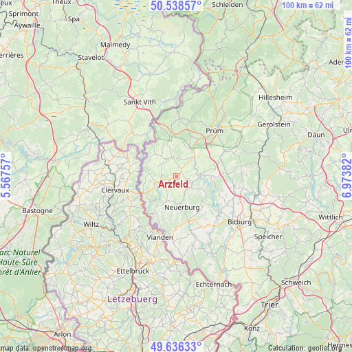
Arzfeld GPS coordinates[2]
50° 5' 22.452" North, 6° 16' 14.484" East
| Map corner | latitude | longitude |
|---|---|---|
| Upper-left | 50.53857°, | 5.56757° |
| Center: | 50.08957°, | 6.27069° |
| Lower-right: | 49.63633°, | 6.97382° |
| Map W x H: | 100.3×100.3 km | = 62.3×62.3mi |
| max Lat: | 55.01917° ⇑61.5% North |
| Arzfeld: | 50.08957° |
| min Lat: | ⇓38.5% South 47.40724° |
| min Long | Arzfeld | max Long |
| 5.92978° | 6.27069° | 14.98853° |
| W 0.7%⇐ | ⇒99.3% E |
Elevation
Elevation of Arzfeld is 498 m = 1634 ft, and this is 248.9 m = 817 ft above average elevation for this country.
| Max E: |
1256 m = 4121 ft | 11.6% |
| Arzfeld | 498 m 1634 ft | |
| Avg. | 249.1 m = 817 ft | |
Min E: |
-5 m = -16 ft | 88.4% |
See also: Germany elevation on elevation.city.
Geographical zone
Arzfeld is located in North temperate zone (between Tropic of Cancer and the Arctic Circle). Distance of this North polar circle is 1831.7 km =1138.2 mi to North.| Distance of | km | miles | from Arzfeld |
|---|---|---|---|
| North Pole | 4437.6 | 2757.4 | to North |
| Arctic Circle | 1831.7 | 1138.2 | to North |
| Tropic Cancer | 2963.5 | 1841.4 | to South |
| Equator | 5569.4 | 3460.7 | to South |


Nearby cities:
15 places around Arzfeld: (largest is in red/bold)
• Emmelbaum
4.4 km =2.7 mi,  183°
183°
• Eschfeld
5.9 km =3.7 mi,  300°
300°
• Euscheid
5.3 km =3.3 mi,  23°
23°
• Heilbach
4.5 km =2.8 mi,  168°
168°
• Irrhausen
5.7 km =3.5 mi,  243°
243°
• Jucken
5.1 km =3.2 mi,  211°
211°
• Kickeshausen
2.9 km =1.8 mi, 210°
• Krautscheid
5.1 km =3.2 mi,  119°
119°
• Lauperath
4.5 km =2.8 mi,  98°
98°
• Lichtenborn
3.7 km =2.3 mi,  34°
34°
• Manderscheid
5.8 km =3.6 mi,  78°
78°
• Olmscheid
4.6 km =2.9 mi, 236°
• Reiff
5.2 km =3.2 mi,  282°
282°
• Sengerich
4.9 km =3 mi,  308°
308°
• Strickscheid
5.9 km =3.7 mi, 33°
Sources, notices
• [Note1] Compared only with cities in Germany existing in our database
• [Src1] Map data: © OpenStreetMap contributors (CC-BY-SA)
• [Src2] Other city data from geonames.org with taken over terms of usage.
• [Src3] Geographical zone / Annual Mean Temperature by Robert A. Rohde @ Wikipedia
