Allendorf geodata
Allendorf (Rheinland-Pfalz) is a seat of a fourth-order administrative division; located in Germany in Europe/Berlin (GMT+2) time zone. With population of 694 people, there are 8345 cities with bigger population in this country. Compared to other cities in Germany, 57.3% of cities are located further ↑North; 77.2% of cities are located further →East and 65.8% of cities have lower elevation than Allendorf. Note1


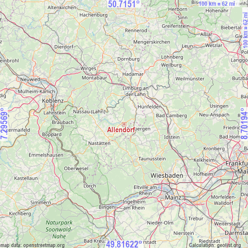
Allendorf GPS coordinates[2]
50° 16' 4.008" North, 7° 59' 55.752" East
| Map corner | latitude | longitude |
|---|---|---|
| Upper-left | 50.7151°, | 7.29569° |
| Center: | 50.26778°, | 7.99882° |
| Lower-right: | 49.81622°, | 8.70194° |
| Map W x H: | 99.9×99.9 km | = 62.1×62.1mi |
| max Lat: | 55.01917° ⇑57.3% North |
| Allendorf: | 50.26778° |
| min Lat: | ⇓42.7% South 47.40724° |
| min Long | Allendorf | max Long |
| 5.92978° | 7.99882° | 14.98853° |
| W 22.8%⇐ | ⇒77.2% E |
Elevation
Elevation of Allendorf is 327 m = 1073 ft, and this is 77.9 m = 256 ft above average elevation for this country.
| Max E: |
1256 m = 4121 ft | 34.2% |
| Allendorf | 327 m 1073 ft | |
| Avg. | 249.1 m = 817 ft | |
Min E: |
-5 m = -16 ft | 65.8% |
See also: Germany elevation on elevation.city.
Geographical zone
Allendorf is located in North temperate zone (between Tropic of Cancer and the Arctic Circle). Distance of this North polar circle is 1811.9 km =1125.9 mi to North.| Distance of | km | miles | from Allendorf |
|---|---|---|---|
| North Pole | 4417.8 | 2745.1 | to North |
| Arctic Circle | 1811.9 | 1125.9 | to North |
| Tropic Cancer | 2983.3 | 1853.7 | to South |
| Equator | 5589.3 | 3473 | to South |


Nearby cities:
15 places around Allendorf: (largest is in red/bold)
• Berghausen
1.1 km =0.7 mi,  148°
148°
• Berndroth
4 km =2.5 mi,  211°
211°
• Dörsdorf
2.5 km =1.6 mi,  162°
162°
• Ebertshausen
2 km =1.2 mi,  327°
327°
• Eisighofen
4 km =2.5 mi, 161°
• Ergeshausen
4 km =2.5 mi,  276°
276°
• Herold
4.9 km =3 mi, 282°
• Katzenelnbogen
1.8 km =1.1 mi,  268°
268°
• Klingelbach
2.2 km =1.4 mi,  292°
292°
• Mittelfischbach
3.1 km =1.9 mi,  239°
239°
• Mudershausen
3 km =1.9 mi,  54°
54°
• Oberfischbach
3.7 km =2.3 mi, 236°
• Reckenroth
4.6 km =2.9 mi, 157°
• Schiesheim
4.1 km =2.5 mi,  75°
75°
• Schönborn
3.9 km =2.4 mi,  354°
354°
Sources, notices
• [Note1] Compared only with cities in Germany existing in our database
• [Src1] Map data: © OpenStreetMap contributors (CC-BY-SA)
• [Src2] Other city data from geonames.org with taken over terms of usage.
• [Src3] Geographical zone / Annual Mean Temperature by Robert A. Rohde @ Wikipedia
