Albersweiler geodata
Albersweiler (Rheinland-Pfalz) is a seat of a fourth-order administrative division; located in Germany in Europe/Berlin (GMT+2) time zone. With population of 1,929 people, there are 5169 cities with bigger population in this country. Compared to other cities in Germany, 80.1% of cities are located further ↑North; 76.6% of cities are located further →East and 57.8% of cities have higher elevation than Albersweiler. Note1
Administrative division(s):
- Level 1: Rheinland-Pfalz
- Level 3: Landkreis Südliche Weinstraße
- Level 4: Albersweiler


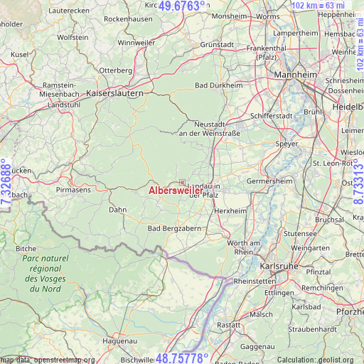
Albersweiler GPS coordinates[2]
49° 13' 9.012" North, 8° 1' 48" East
| Map corner | latitude | longitude |
|---|---|---|
| Upper-left | 49.6763°, | 7.32688° |
| Center: | 49.21917°, | 8.03° |
| Lower-right: | 48.75778°, | 8.73313° |
| Map W x H: | 102.1×102.1 km | = 63.4×63.4mi |
| max Lat: | 55.01917° ⇑80.1% North |
| Albersweiler: | 49.21917° |
| min Lat: | ⇓19.9% South 47.40724° |
| min Long | Albersweiler | max Long |
| 5.92978° | 8.03° | 14.98853° |
| W 23.4%⇐ | ⇒76.6% E |
Elevation
Elevation of Albersweiler is 169 m = 554 ft, and this is 80.1 m = 263 ft below average elevation for this country.
| Max E: |
1256 m = 4121 ft | 57.8% |
| Avg. | 249.1 m = 817 ft | |
| Albersweiler | 169 m = 554 ft | |
Min E: |
-5 m = -16 ft | 42.2% |
See also: Germany elevation on elevation.city.
Geographical zone
Albersweiler is located in North temperate zone (between Tropic of Cancer and the Arctic Circle). Distance of this North polar circle is 1928.5 km =1198.3 mi to North.| Distance of | km | miles | from Albersweiler |
|---|---|---|---|
| North Pole | 4534.4 | 2817.5 | to North |
| Arctic Circle | 1928.5 | 1198.3 | to North |
| Tropic Cancer | 2866.7 | 1781.3 | to South |
| Equator | 5472.7 | 3400.6 | to South |


Nearby cities:
15 places around Albersweiler: (largest is in red/bold)
• Annweiler am Trifels
4.2 km =2.6 mi,  249°
249°
• Birkweiler
1.9 km =1.2 mi,  161°
161°
• Burrweiler
4.7 km =2.9 mi,  47°
47°
• Böchingen
5 km =3.1 mi,  66°
66°
• Dernbach
3.6 km =2.2 mi,  330°
330°
• Eschbach
5 km =3.1 mi,  188°
188°
• Eußerthal
5.7 km =3.5 mi,  306°
306°
• Flemlingen
5.4 km =3.4 mi,  60°
60°
• Frankweiler
2.3 km =1.4 mi, 64°
• Gleisweiler
3.8 km =2.4 mi, 48°
• Ilbesheim
4.4 km =2.7 mi, 157°
• Leinsweiler
4.1 km =2.5 mi, 191°
• Ramberg
4.8 km =3 mi,  341°
341°
• Ranschbach
2.6 km =1.6 mi,  182°
182°
• Siebeldingen
1.9 km =1.2 mi,  126°
126°
Sources, notices
• [Note1] Compared only with cities in Germany existing in our database
• [Src1] Map data: © OpenStreetMap contributors (CC-BY-SA)
• [Src2] Other city data from geonames.org with taken over terms of usage.
• [Src3] Geographical zone / Annual Mean Temperature by Robert A. Rohde @ Wikipedia
