Burrweiler geodata
Burrweiler (Rheinland-Pfalz) is a seat of a fourth-order administrative division; located in Germany in Europe/Berlin (GMT+2) time zone. With population of 898 people, there are 7531 cities with bigger population in this country. Compared to other cities in Germany, 79.6% of cities are located further ↑North; 75.8% of cities are located further →East and 52.3% of cities have lower elevation than Burrweiler. Note1
Administrative division(s):
- Level 1: Rheinland-Pfalz
- Level 3: Landkreis Südliche Weinstraße
- Level 4: Burrweiler


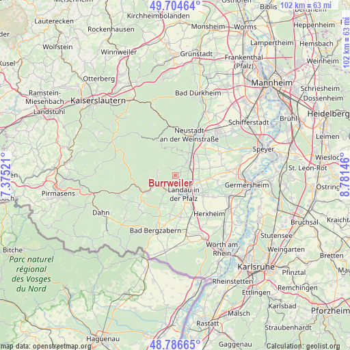
Burrweiler GPS coordinates[2]
49° 14' 52.008" North, 8° 4' 41.988" East
| Map corner | latitude | longitude |
|---|---|---|
| Upper-left | 49.70464°, | 7.37521° |
| Center: | 49.24778°, | 8.07833° |
| Lower-right: | 48.78665°, | 8.78146° |
| Map W x H: | 102.1×102.1 km | = 63.4×63.4mi |
| max Lat: | 55.01917° ⇑79.6% North |
| Burrweiler: | 49.24778° |
| min Lat: | ⇓20.4% South 47.40724° |
| min Long | Burrweiler | max Long |
| 5.92978° | 8.07833° | 14.98853° |
| W 24.2%⇐ | ⇒75.8% E |
Elevation
Elevation of Burrweiler is 242 m = 794 ft, and this is 7.1 m = 23 ft below average elevation for this country.
| Max E: |
1256 m = 4121 ft | 47.7% |
| Avg. | 249.1 m = 817 ft | |
| Burrweiler | 242 m = 794 ft | |
Min E: |
-5 m = -16 ft | 52.3% |
See also: Germany elevation on elevation.city.
Geographical zone
Burrweiler is located in North temperate zone (between Tropic of Cancer and the Arctic Circle). Distance of this North polar circle is 1925.3 km =1196.3 mi to North.| Distance of | km | miles | from Burrweiler |
|---|---|---|---|
| North Pole | 4531.2 | 2815.6 | to North |
| Arctic Circle | 1925.3 | 1196.3 | to North |
| Tropic Cancer | 2869.9 | 1783.3 | to South |
| Equator | 5475.8 | 3402.5 | to South |


Nearby cities:
15 places around Burrweiler: (largest is in red/bold)
• Albersweiler
4.7 km =2.9 mi,  227°
227°
• Böchingen
1.6 km =1 mi,  137°
137°
• Dernbach
5.3 km =3.3 mi,  269°
269°
• Edesheim
4.5 km =2.8 mi,  67°
67°
• Flemlingen
1.3 km =0.8 mi,  114°
114°
• Frankweiler
2.7 km =1.7 mi,  213°
213°
• Gleisweiler
0.9 km =0.6 mi, 226°
• Hainfeld
2 km =1.2 mi,  56°
56°
• Knöringen
4.9 km =3 mi,  103°
103°
• Ramberg
5.3 km =3.3 mi,  285°
285°
• Rhodt unter Rietburg
3.2 km =2 mi,  41°
41°
• Roschbach
2.9 km =1.8 mi,  93°
93°
• Siebeldingen
4.7 km =2.9 mi,  204°
204°
• Walsheim
3.7 km =2.3 mi, 108°
• Weyher
2.3 km =1.4 mi,  12°
12°
Sources, notices
• [Note1] Compared only with cities in Germany existing in our database
• [Src1] Map data: © OpenStreetMap contributors (CC-BY-SA)
• [Src2] Other city data from geonames.org with taken over terms of usage.
• [Src3] Geographical zone / Annual Mean Temperature by Robert A. Rohde @ Wikipedia
