Ramberg geodata
Ramberg (Rheinland-Pfalz) is a seat of a fourth-order administrative division; located in Germany in Europe/Berlin (GMT+2) time zone. With population of 1,018 people, there are 7125 cities with bigger population in this country. Compared to other cities in Germany, 79.4% of cities are located further ↑North; 77% of cities are located further →East and 51.3% of cities have lower elevation than Ramberg. Note1
Administrative division(s):
- Level 1: Rheinland-Pfalz
- Level 3: Landkreis Südliche Weinstraße
- Level 4: Ramberg


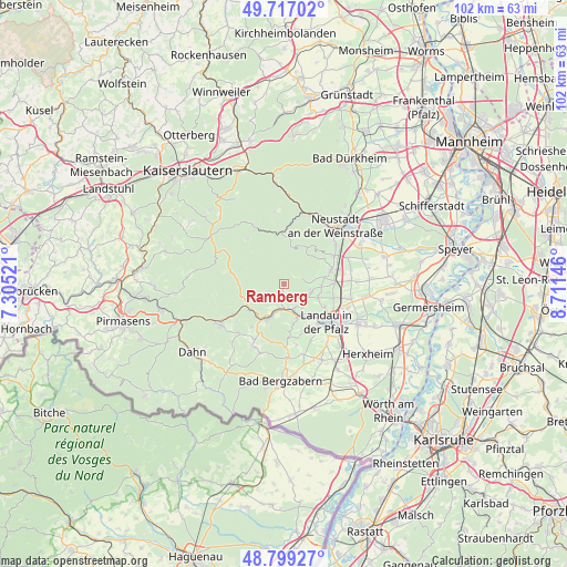
Ramberg GPS coordinates[2]
49° 15' 37.008" North, 8° 0' 29.988" East
| Map corner | latitude | longitude |
|---|---|---|
| Upper-left | 49.71702°, | 7.30521° |
| Center: | 49.26028°, | 8.00833° |
| Lower-right: | 48.79927°, | 8.71146° |
| Map W x H: | 102×102 km | = 63.4×63.4mi |
| max Lat: | 55.01917° ⇑79.4% North |
| Ramberg: | 49.26028° |
| min Lat: | ⇓20.6% South 47.40724° |
| min Long | Ramberg | max Long |
| 5.92978° | 8.00833° | 14.98853° |
| W 23%⇐ | ⇒77% E |
Elevation
Elevation of Ramberg is 235 m = 771 ft, and this is 14.1 m = 46 ft below average elevation for this country.
| Max E: |
1256 m = 4121 ft | 48.7% |
| Avg. | 249.1 m = 817 ft | |
| Ramberg | 235 m = 771 ft | |
Min E: |
-5 m = -16 ft | 51.3% |
See also: Germany elevation on elevation.city.
Geographical zone
Ramberg is located in North temperate zone (between Tropic of Cancer and the Arctic Circle). Distance of this North polar circle is 1923.9 km =1195.5 mi to North.| Distance of | km | miles | from Ramberg |
|---|---|---|---|
| North Pole | 4529.8 | 2814.7 | to North |
| Arctic Circle | 1923.9 | 1195.5 | to North |
| Tropic Cancer | 2871.3 | 1784.1 | to South |
| Equator | 5477.2 | 3403.4 | to South |


Nearby cities:
15 places around Ramberg: (largest is in red/bold)
• Albersweiler
4.8 km =3 mi,  161°
161°
• Annweiler am Trifels
6.5 km =4 mi,  201°
201°
• Birkweiler
6.7 km =4.2 mi, 161°
• Burrweiler
5.3 km =3.3 mi,  105°
105°
• Böchingen
6.7 km =4.2 mi, 112°
• Dernbach
1.5 km =0.9 mi,  188°
188°
• Eußerthal
3.2 km =2 mi,  249°
249°
• Flemlingen
6.6 km =4.1 mi, 107°
• Frankweiler
5.1 km =3.2 mi,  135°
135°
• Gleisweiler
4.9 km =3 mi, 114°
• Hainfeld
6.7 km =4.2 mi,  92°
92°
• Ranschbach
7.3 km =4.5 mi,  168°
168°
• Rhodt unter Rietburg
7.3 km =4.5 mi,  81°
81°
• Siebeldingen
6.5 km =4 mi,  151°
151°
• Weyher
5.6 km =3.5 mi, 81°
Sources, notices
• [Note1] Compared only with cities in Germany existing in our database
• [Src1] Map data: © OpenStreetMap contributors (CC-BY-SA)
• [Src2] Other city data from geonames.org with taken over terms of usage.
• [Src3] Geographical zone / Annual Mean Temperature by Robert A. Rohde @ Wikipedia
