Adenbüttel geodata
Adenbüttel (Lower Saxony) is a seat of a fourth-order administrative division; located in Germany in Europe/Berlin (GMT+2) time zone. With population of 1,762 people, there are 5410 cities with bigger population in this country. Compared to other cities in Germany, 76% of cities are located further ↓South; 58.1% of cities are located further ←West and 72.6% of cities have higher elevation than Adenbüttel. Note1


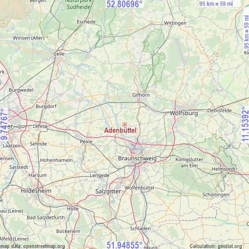
Adenbüttel GPS coordinates[2]
52° 22' 47.424" North, 10° 27' 2.844" East
| Map corner | latitude | longitude |
|---|---|---|
| Upper-left | 52.80696°, | 9.74767° |
| Center: | 52.37984°, | 10.45079° |
| Lower-right: | 51.94855°, | 11.15392° |
| Map W x H: | 95.4×95.4 km | = 59.3×59.3mi |
| max Lat: | 55.01917° ⇑24% North |
| Adenbüttel: | 52.37984° |
| min Lat: | ⇓76% South 47.40724° |
| min Long | Adenbüttel | max Long |
| 5.92978° | 10.45079° | 14.98853° |
| W 58.1%⇐ | ⇒41.9% E |
Elevation
Elevation of Adenbüttel is 74 m = 243 ft, and this is 175.1 m = 574 ft below average elevation for this country.
| Max E: |
1256 m = 4121 ft | 72.6% |
| Avg. | 249.1 m = 817 ft | |
| Adenbüttel | 74 m = 243 ft | |
Min E: |
-5 m = -16 ft | 27.4% |
See also: Germany elevation on elevation.city.
Geographical zone
Adenbüttel is located in North temperate zone (between Tropic of Cancer and the Arctic Circle). Distance of this North polar circle is 1577.1 km =980 mi to North.| Distance of | km | miles | from Adenbüttel |
|---|---|---|---|
| North Pole | 4183 | 2599.2 | to North |
| Arctic Circle | 1577.1 | 980 | to North |
| Tropic Cancer | 3218.2 | 1999.7 | to South |
| Equator | 5824.1 | 3618.9 | to South |


Nearby cities:
15 places around Adenbüttel: (largest is in red/bold)
• Abbesbüttel
7.8 km =4.8 mi,  113°
113°
• Bechtsbüttel
7.6 km =4.7 mi,  127°
127°
• Bevenrode
9.7 km =6 mi,  117°
117°
• Didderse
3.2 km =2 mi,  271°
271°
• Hillerse
5.4 km =3.4 mi,  319°
319°
• Klein Schwülper
4.5 km =2.8 mi,  199°
199°
• Leiferde
6.7 km =4.2 mi,  350°
350°
• Meerdorf
9.8 km =6.1 mi,  247°
247°
• Meine
6 km =3.7 mi,  84°
84°
• Neubrück
2.5 km =1.6 mi, 246°
• Rethen
1.9 km =1.2 mi,  99°
99°
• Ribbesbüttel
7.3 km =4.5 mi,  33°
33°
• Rötgesbüttel
6.9 km =4.3 mi,  53°
53°
• Vordorf
5 km =3.1 mi, 108°
• Wendeburg
6.8 km =4.2 mi,  215°
215°
Sources, notices
• [Note1] Compared only with cities in Germany existing in our database
• [Src1] Map data: © OpenStreetMap contributors (CC-BY-SA)
• [Src2] Other city data from geonames.org with taken over terms of usage.
• [Src3] Geographical zone / Annual Mean Temperature by Robert A. Rohde @ Wikipedia
