Meine geodata
Meine (Lower Saxony) is a seat of a fourth-order administrative division; located in Germany in Europe/Berlin (GMT+2) time zone. In our database, there are 11009 cities with bigger population. Compared to other cities in Germany, 76% of cities are located further ↓South; 59.6% of cities are located further ←West and 71.8% of cities have higher elevation than Meine. Note1


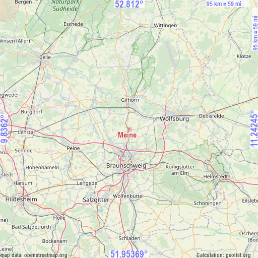
Meine GPS coordinates[2]
52° 23' 5.748" North, 10° 32' 21.552" East
| Map corner | latitude | longitude |
|---|---|---|
| Upper-left | 52.812°, | 9.8362° |
| Center: | 52.38493°, | 10.53932° |
| Lower-right: | 51.95369°, | 11.24245° |
| Map W x H: | 95.4×95.4 km | = 59.3×59.3mi |
| max Lat: | 55.01917° ⇑24% North |
| Meine: | 52.38493° |
| min Lat: | ⇓76% South 47.40724° |
| min Long | Meine | max Long |
| 5.92978° | 10.53932° | 14.98853° |
| W 59.6%⇐ | ⇒40.4% E |
Elevation
Elevation of Meine is 79 m = 259 ft, and this is 170.1 m = 558 ft below average elevation for this country.
| Max E: |
1256 m = 4121 ft | 71.8% |
| Avg. | 249.1 m = 817 ft | |
| Meine | 79 m = 259 ft | |
Min E: |
-5 m = -16 ft | 28.2% |
See also: Germany elevation on elevation.city.
Geographical zone
Meine is located in North temperate zone (between Tropic of Cancer and the Arctic Circle). Distance of this North polar circle is 1576.5 km =979.6 mi to North.| Distance of | km | miles | from Meine |
|---|---|---|---|
| North Pole | 4182.4 | 2598.8 | to North |
| Arctic Circle | 1576.5 | 979.6 | to North |
| Tropic Cancer | 3218.7 | 2000 | to South |
| Equator | 5824.7 | 3619.3 | to South |


Nearby cities:
15 places around Meine: (largest is in red/bold)
• Abbesbüttel
3.8 km =2.4 mi,  162°
162°
• Adenbüttel
6 km =3.7 mi,  264°
264°
• Allerbüttel
7.8 km =4.8 mi,  59°
59°
• Bechtsbüttel
5.2 km =3.2 mi,  179°
179°
• Bevenrode
5.6 km =3.5 mi,  152°
152°
• Calberlah
6.9 km =4.3 mi, 55°
• Didderse
9.3 km =5.8 mi,  266°
266°
• Isenbüttel
6.2 km =3.9 mi,  29°
29°
• Klein Schwülper
8.9 km =5.5 mi,  237°
237°
• Neubrück
8.4 km =5.2 mi, 259°
• Rethen
4.2 km =2.6 mi, 258°
• Ribbesbüttel
5.8 km =3.6 mi,  340°
340°
• Rötgesbüttel
3.6 km =2.2 mi,  353°
353°
• Vordorf
2.5 km =1.6 mi,  210°
210°
• Wasbüttel
4.8 km =3 mi,  49°
49°
Sources, notices
• [Note1] Compared only with cities in Germany existing in our database
• [Src1] Map data: © OpenStreetMap contributors (CC-BY-SA)
• [Src2] Other city data from geonames.org with taken over terms of usage.
• [Src3] Geographical zone / Annual Mean Temperature by Robert A. Rohde @ Wikipedia
