Elben geodata
Elben (Rheinland-Pfalz) is a seat of a fourth-order administrative division; located in Germany in Europe/Berlin (GMT+2) time zone. In our database, there are 11009 cities with bigger population. Compared to other cities in Germany, 53.2% of cities are located further ↓South; 80.4% of cities are located further →East and 60.2% of cities have lower elevation than Elben. Note1


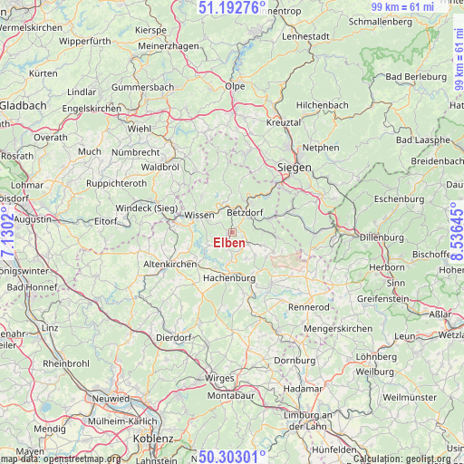
Elben GPS coordinates[2]
50° 45' 0" North, 7° 49' 59.988" East
| Map corner | latitude | longitude |
|---|---|---|
| Upper-left | 51.19276°, | 7.1302° |
| Center: | 50.75°, | 7.83333° |
| Lower-right: | 50.30301°, | 8.53645° |
| Map W x H: | 98.9×98.9 km | = 61.5×61.5mi |
| max Lat: | 55.01917° ⇑46.8% North |
| Elben: | 50.75° |
| min Lat: | ⇓53.2% South 47.40724° |
| min Long | Elben | max Long |
| 5.92978° | 7.83333° | 14.98853° |
| W 19.6%⇐ | ⇒80.4% E |
Elevation
Elevation of Elben is 291 m = 955 ft, and this is 41.9 m = 137 ft above average elevation for this country.
| Max E: |
1256 m = 4121 ft | 39.8% |
| Elben | 291 m 955 ft | |
| Avg. | 249.1 m = 817 ft | |
Min E: |
-5 m = -16 ft | 60.2% |
See also: Germany elevation on elevation.city.
Geographical zone
Elben is located in North temperate zone (between Tropic of Cancer and the Arctic Circle). Distance of this North polar circle is 1758.3 km =1092.6 mi to North.| Distance of | km | miles | from Elben |
|---|---|---|---|
| North Pole | 4364.2 | 2711.8 | to North |
| Arctic Circle | 1758.3 | 1092.6 | to North |
| Tropic Cancer | 3037 | 1887.1 | to South |
| Equator | 5642.9 | 3506.3 | to South |


Nearby cities:
15 places around Elben: (largest is in red/bold)
• Alsdorf
4.8 km =3 mi,  50°
50°
• Dickendorf
2.2 km =1.4 mi,  147°
147°
• Elkenroth
4 km =2.5 mi,  117°
117°
• Fensdorf
5 km =3.1 mi,  248°
248°
• Gebhardshain
1.2 km =0.7 mi,  270°
270°
• Kausen
2.6 km =1.6 mi,  111°
111°
• Kundert
4.5 km =2.8 mi,  219°
219°
• Mittelhof
3.4 km =2.1 mi,  324°
324°
• Molzhain
1.2 km =0.7 mi,  90°
90°
• Mörsbach
4.4 km =2.7 mi,  233°
233°
• Rosenheim
4.4 km =2.7 mi,  163°
163°
• Scheuerfeld
4.2 km =2.6 mi,  7°
7°
• Schutzbach
4.7 km =2.9 mi, 90°
• Selbach
4.5 km =2.8 mi,  264°
264°
• Steineroth
1.9 km =1.2 mi, 52°
Sources, notices
• [Note1] Compared only with cities in Germany existing in our database
• [Src1] Map data: © OpenStreetMap contributors (CC-BY-SA)
• [Src2] Other city data from geonames.org with taken over terms of usage.
• [Src3] Geographical zone / Annual Mean Temperature by Robert A. Rohde @ Wikipedia
