Florstadt geodata
Florstadt (Hesse) is a seat of a fourth-order administrative division; located in Germany in Europe/Berlin (GMT+2) time zone. With population of 8,905 people, there are 1808 cities with bigger population in this country. Compared to other cities in Germany, 56.5% of cities are located further ↑North; 67.1% of cities are located further →East and 62.3% of cities have higher elevation than Florstadt. Note1
Administrative division(s):
- Level 1: Hesse
- Level 2: Regierungsbezirk Darmstadt
- Level 3: Wetteraukreis
- Level 4: Florstadt


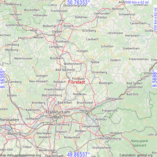
Florstadt GPS coordinates[2]
50° 19' 0.012" North, 8° 52' 0.012" East
| Map corner | latitude | longitude |
|---|---|---|
| Upper-left | 50.76353°, | 8.16355° |
| Center: | 50.31667°, | 8.86667° |
| Lower-right: | 49.86557°, | 9.5698° |
| Map W x H: | 99.8×99.8 km | = 62×62mi |
| max Lat: | 55.01917° ⇑56.5% North |
| Florstadt: | 50.31667° |
| min Lat: | ⇓43.5% South 47.40724° |
| min Long | Florstadt | max Long |
| 5.92978° | 8.86667° | 14.98853° |
| W 32.9%⇐ | ⇒67.1% E |
Elevation
Elevation of Florstadt is 136 m = 446 ft, and this is 113.1 m = 371 ft below average elevation for this country.
| Max E: |
1256 m = 4121 ft | 62.3% |
| Avg. | 249.1 m = 817 ft | |
| Florstadt | 136 m = 446 ft | |
Min E: |
-5 m = -16 ft | 37.7% |
See also: Germany elevation on elevation.city.
Geographical zone
Florstadt is located in North temperate zone (between Tropic of Cancer and the Arctic Circle). Distance of this North polar circle is 1806.5 km =1122.5 mi to North.| Distance of | km | miles | from Florstadt |
|---|---|---|---|
| North Pole | 4412.4 | 2741.7 | to North |
| Arctic Circle | 1806.5 | 1122.5 | to North |
| Tropic Cancer | 2988.8 | 1857.2 | to South |
| Equator | 5594.7 | 3476.4 | to South |


Nearby cities:
15 places around Florstadt: (largest is in red/bold)
• Altenstadt
6.4 km =4 mi,  120°
120°
• Bad Nauheim
10.5 km =6.5 mi,  300°
300°
• Berstadt
12.2 km =7.6 mi,  359°
359°
• Echzell
8.1 km =5 mi,  9°
9°
• Friedberg
8.2 km =5.1 mi,  286°
286°
• Glauburg
9.5 km =5.9 mi,  90°
90°
• Karben
11.8 km =7.3 mi,  215°
215°
• Melbach
8 km =5 mi,  329°
329°
• Nidderau
8.7 km =5.4 mi,  179°
179°
• Ranstadt
9.5 km =5.9 mi,  61°
61°
• Reichelsheim
4.4 km =2.7 mi, 7°
• Rosbach vor der Höhe
12.6 km =7.8 mi,  263°
263°
• Södel
9.6 km =6 mi, 332°
• Wohnbach
12.7 km =7.9 mi,  347°
347°
• Wölfersheim
9.9 km =6.2 mi,  339°
339°
Sources, notices
• [Note1] Compared only with cities in Germany existing in our database
• [Src1] Map data: © OpenStreetMap contributors (CC-BY-SA)
• [Src2] Other city data from geonames.org with taken over terms of usage.
• [Src3] Geographical zone / Annual Mean Temperature by Robert A. Rohde @ Wikipedia
