Schöffengrund geodata
Schöffengrund (Hesse) is a seat of a fourth-order administrative division; located in Germany in Europe/Berlin (GMT+2) time zone. With population of 6,316 people, there are 2358 cities with bigger population in this country. Compared to other cities in Germany, 53% of cities are located further ↑North; 71.3% of cities are located further →East and 58.8% of cities have lower elevation than Schöffengrund. Note1
Administrative division(s):
- Level 1: Hesse
- Level 2: Regierungsbezirk Gießen
- Level 3: Lahn-Dill-Kreis
- Level 4: Schöffengrund


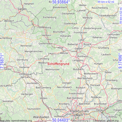
Schöffengrund GPS coordinates[2]
50° 29' 36.42" North, 8° 28' 18.588" East
| Map corner | latitude | longitude |
|---|---|---|
| Upper-left | 50.93864°, | 7.76871° |
| Center: | 50.49345°, | 8.47183° |
| Lower-right: | 50.04403°, | 9.17496° |
| Map W x H: | 99.5×99.5 km | = 61.8×61.8mi |
| max Lat: | 55.01917° ⇑53% North |
| Schöffengrund: | 50.49345° |
| min Lat: | ⇓47% South 47.40724° |
| min Long | Schöffengrund | max Long |
| 5.92978° | 8.47183° | 14.98853° |
| W 28.7%⇐ | ⇒71.3% E |
Elevation
Elevation of Schöffengrund is 283 m = 928 ft, and this is 33.9 m = 111 ft above average elevation for this country.
| Max E: |
1256 m = 4121 ft | 41.2% |
| Schöffengrund | 283 m 928 ft | |
| Avg. | 249.1 m = 817 ft | |
Min E: |
-5 m = -16 ft | 58.8% |
See also: Germany elevation on elevation.city.
Geographical zone
Schöffengrund is located in North temperate zone (between Tropic of Cancer and the Arctic Circle). Distance of this North polar circle is 1786.8 km =1110.3 mi to North.| Distance of | km | miles | from Schöffengrund |
|---|---|---|---|
| North Pole | 4392.7 | 2729.5 | to North |
| Arctic Circle | 1786.8 | 1110.3 | to North |
| Tropic Cancer | 3008.4 | 1869.3 | to South |
| Equator | 5614.3 | 3488.6 | to South |


Nearby cities:
15 places around Schöffengrund: (largest is in red/bold)
• Albshausen
6.1 km =3.8 mi,  336°
336°
• Allendorf an der Lahn
12.3 km =7.6 mi,  58°
58°
• Aßlar
10.9 km =6.8 mi,  356°
356°
• Braunfels
6.3 km =3.9 mi,  292°
292°
• Burgsolms
7.2 km =4.5 mi,  318°
318°
• Grävenwiesbach
11.5 km =7.1 mi,  185°
185°
• Hörnsheim
11.5 km =7.1 mi,  76°
76°
• Laufdorf
2.7 km =1.7 mi, 341°
• Leun
10.3 km =6.4 mi,  308°
308°
• Niederbiel
8.6 km =5.3 mi, 322°
• Oberbiel
7.3 km =4.5 mi,  334°
334°
• Schwalbach
0.4 km =0.2 mi, 334°
• Solms
6.6 km =4.1 mi, 316°
• Weilmünster
9.6 km =6 mi,  224°
224°
• Wetzlar
7.9 km =4.9 mi,  17°
17°
Sources, notices
• [Note1] Compared only with cities in Germany existing in our database
• [Src1] Map data: © OpenStreetMap contributors (CC-BY-SA)
• [Src2] Other city data from geonames.org with taken over terms of usage.
• [Src3] Geographical zone / Annual Mean Temperature by Robert A. Rohde @ Wikipedia
